Executive summary Tuhinga whakarāpopoto
What happened
- On 16 May 2024 the Japanese fishing vessel Chokyu Maru No.68 was inbound to the Auckland pilot boarding area when it grounded on rocks near The Noises island group.
- There were 27 crew on board; nobody was injured and there was no pollution as a consequence of the grounding.
- The vessel sustained a small hole at the bow, heavy scraping of the hull paint and minor damage to the propeller. It was refloated later the same day and towed to an Auckland port facility.
Why it happened
- The vessel’s route from Yaizu, Japan to Auckland, New Zealand was not appraised, planned, documented or resourced before departure as required by industry rules and guidelines and standard seafaring practice.
- The crew responsible for navigation did not use all available means to determine the vessel’s position in relation to navigable and unnavigable waters.
- The vessel was not carrying the appropriate nautical publications and large-scale charts that identified local navigational hazards such as The Noises and its outlying rocks.
- The master was not aware of rocks and islands between the vessel and the pilot boarding area and set a straight-line course that encountered these navigational hazards.
What we can learn
A well-researched and documented voyage plan is of fundamental importance to the safety of navigation.
Who may benefit
Maritime operators, managers, regulators and training facilities may all benefit from the findings in this report.
Factual information Pārongo pono
Narrative
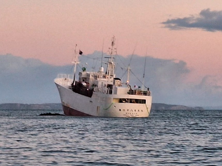
- The Chokyu Maru No.68 was a longline fishing vessel registered in Japan. From July 2023 until March 2024 it was docked at the port of Yaizu, Japan. Early in March 2024, the crew prepared the vessel and its gear for a fishing expedition in the Tasman Sea.
- On 23 March 2024 the Chokyu Maru No.68 departed from Yaizu. The master intended to refuel and load provisions in Auckland, where they and the chief engineer were due to leave the vessel and return to Japan. The chosen route from Yaizu to Auckland generally avoided the Exclusive Economic Zones2 2 (EEZs) of the Pacific Island nations along the way. The master would set a waypoint on the chart plotter and, when that location was reached, set the next waypoint.
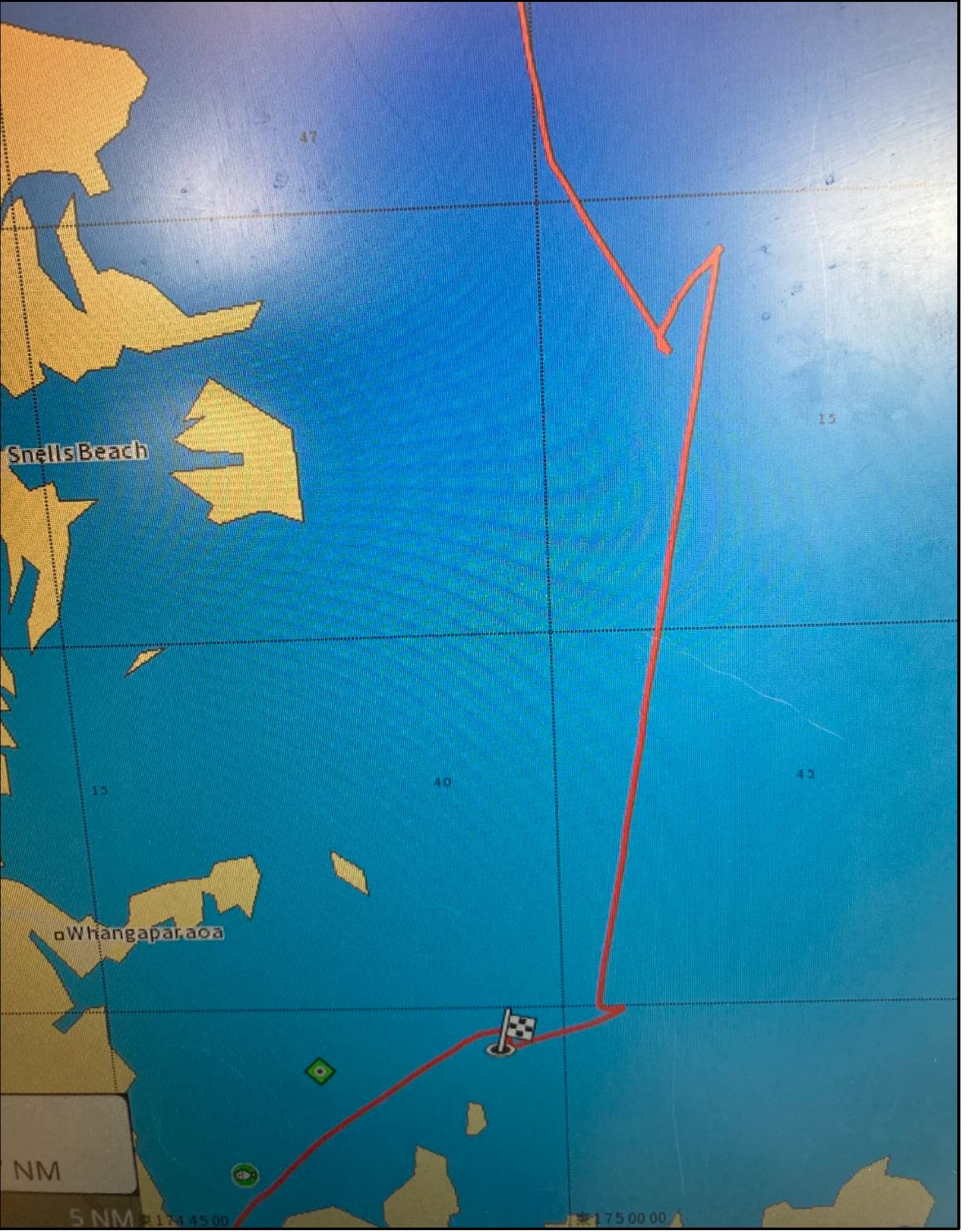
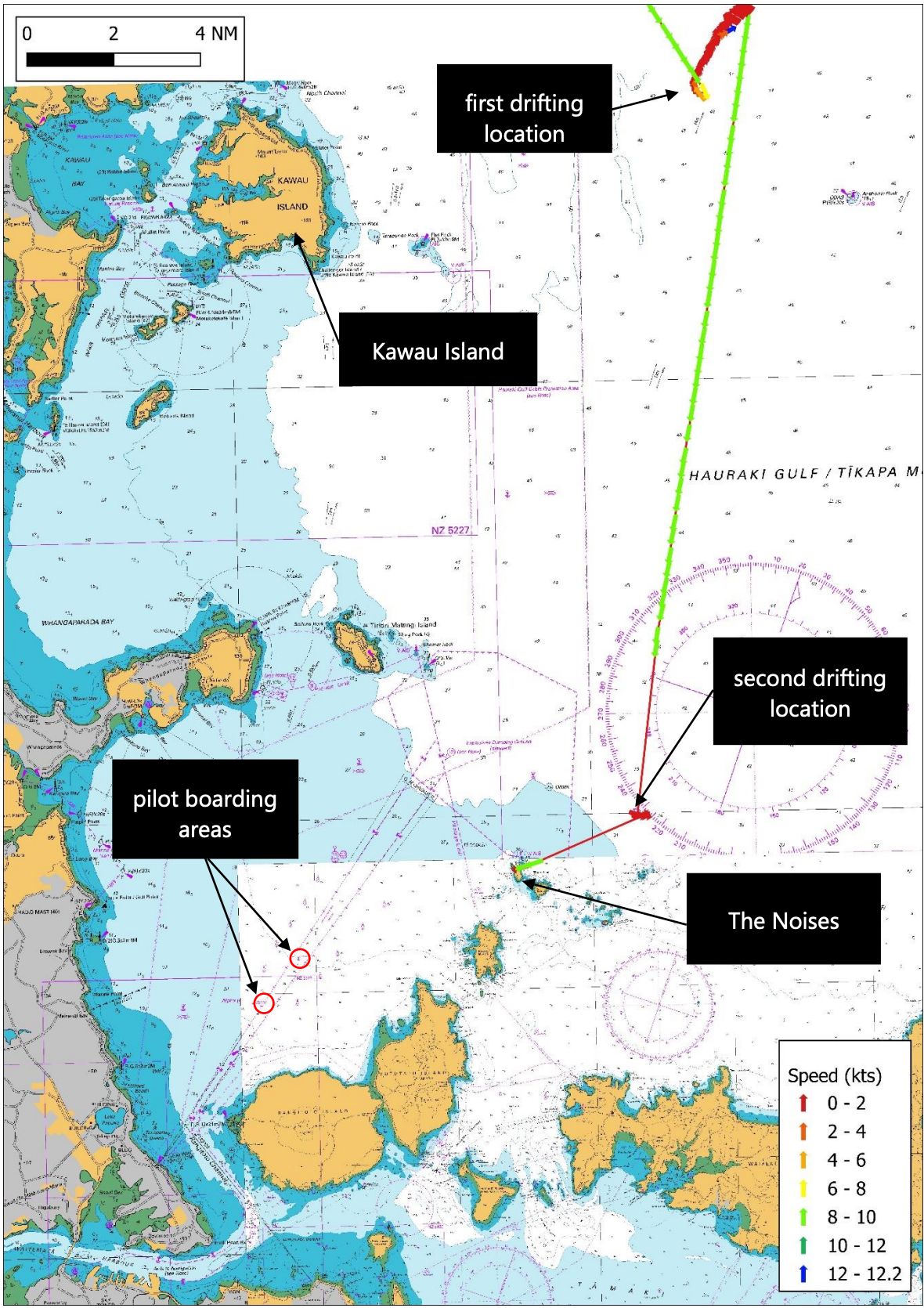
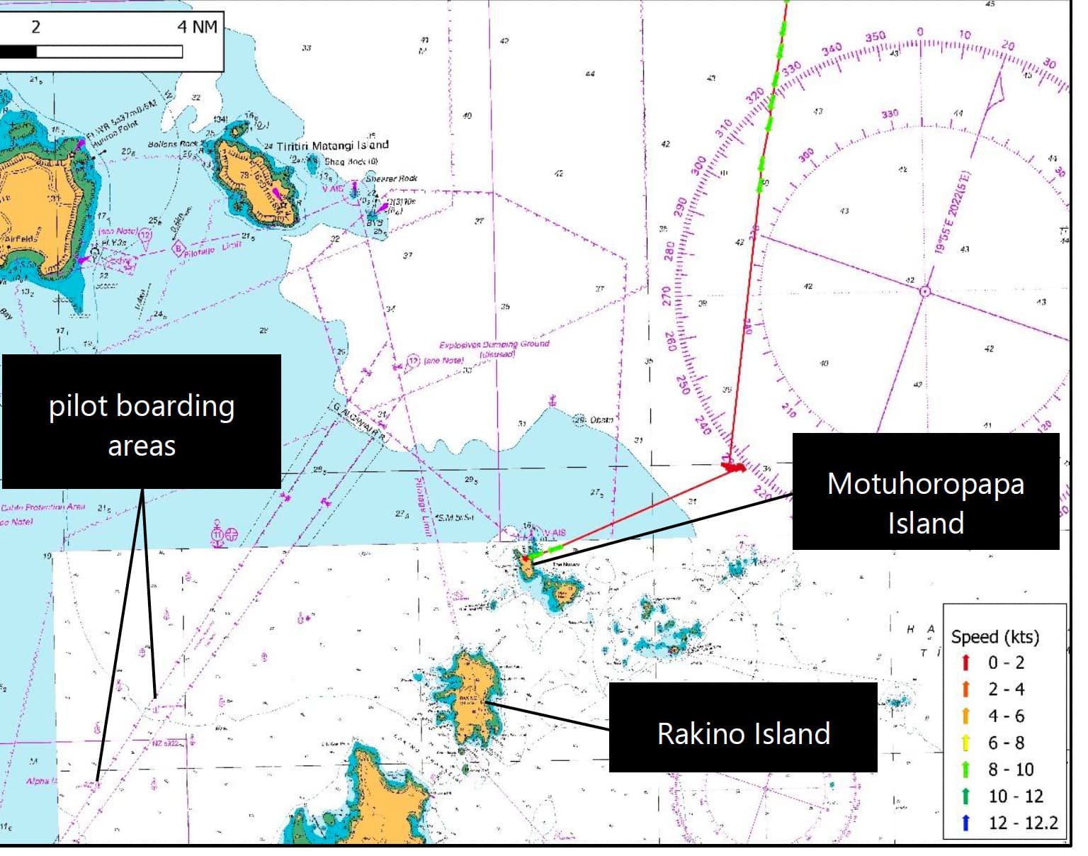
- The Chokyu Maru No.68 arrived in New Zealand waters on 15 April 2024, but was not due at the Auckland pilot boarding area until 0800 (NZST)3 the following day. The master instructed watchkeepers to stop and drift overnight. At about 1825 the watchkeeper stopped the vessel and it drifted east-northeast of Kawau Island for the next five and a half hours. At about 2355 the watchkeeper resumed the vessel’s passage, and at about 0200 they stopped the vessel outside the pilotage limit4 and northeast of The Noises5 (see Figure 3).
- The master came to the bridge at 0245 and along with the chief officer took over the watch at 0300. About 10 minutes later the master resumed the vessel’s approach to the Auckland pilot boarding area and navigated the vessel in a straight line directly from the location where the vessel had been drifting.
(Credit: Land Information New Zealand Toitū Te Whenua, labelled by the Transport Accident Investigation Commission)
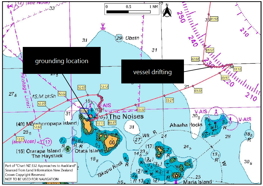
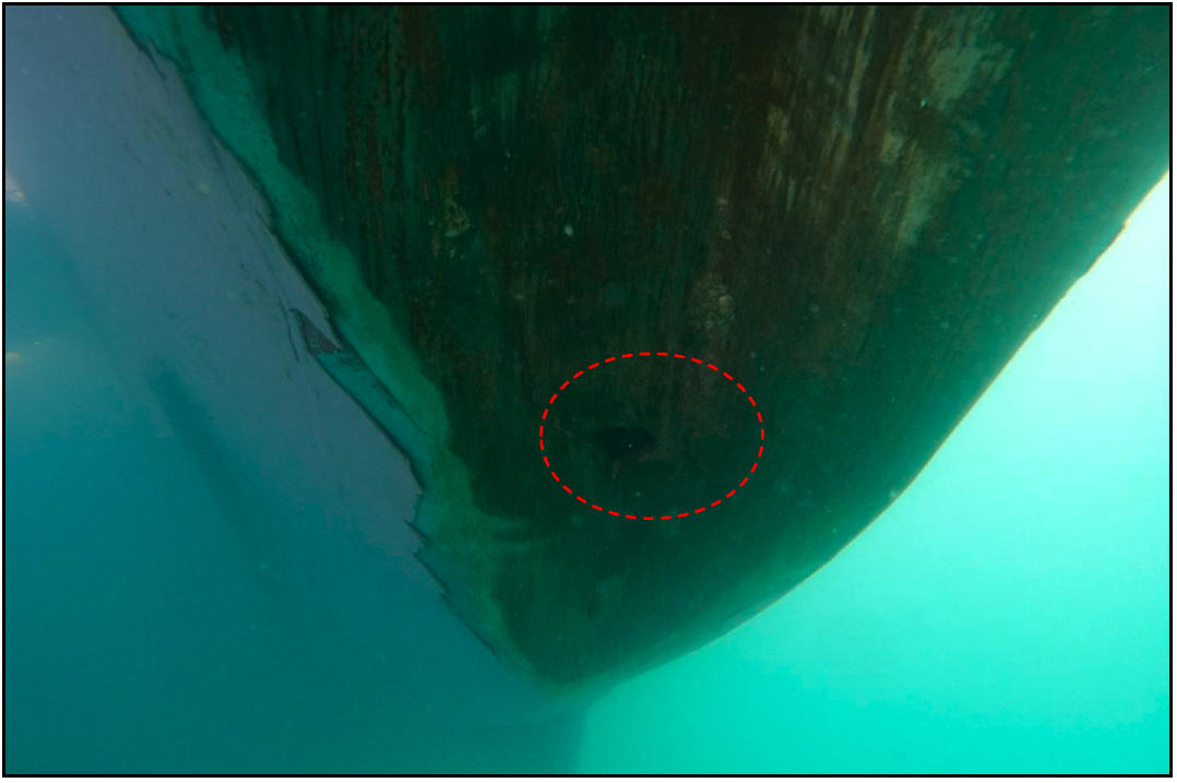
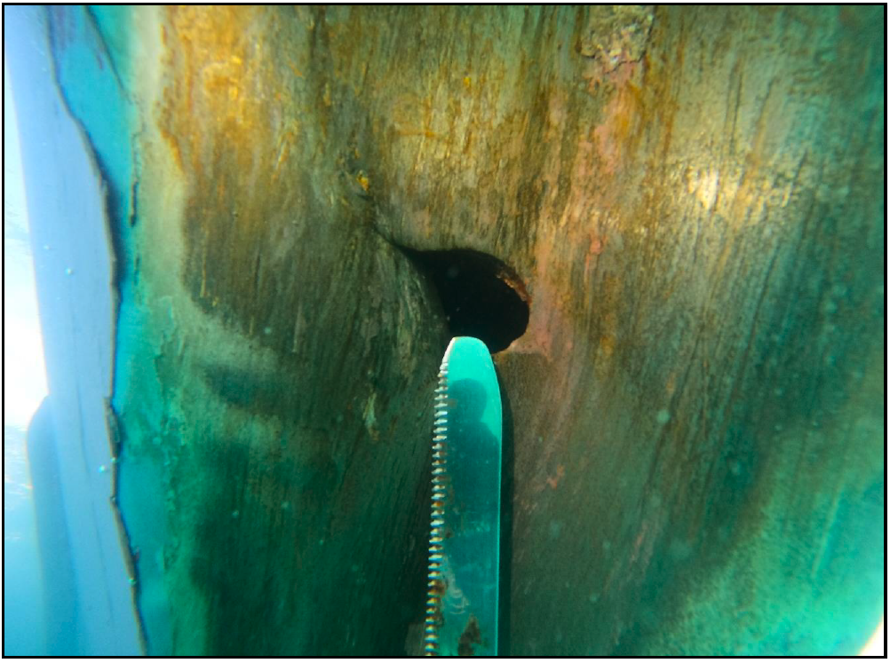
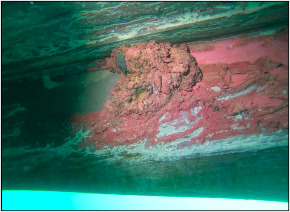
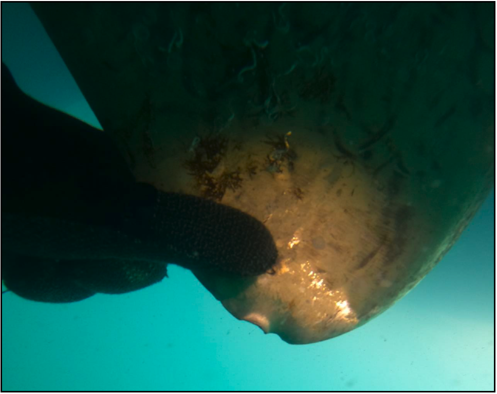
- At approximately 0342, while travelling at a speed of around 8 knots, the Chokyu Maru No.68 ran aground on rocks near Motuhoropapa Island. The vessel was hard aground with the tide ebbing, so at low water6 the bow was high and dry7. Initial inspections made by the crew and the harbourmaster’s staff determined that the damage was limited to scraped hull paint and a hole in the forepeak tank. This was later confirmed by a diver’s inspection of the outside of the hull. The diver also observed a small dent in a propeller blade.
- Between 1000 and 1100 the vessel was refloated. Under the guidance of a local pilot, it was then towed into Waitematā Harbour and berthed at a Ports of Auckland facility.
(Credit: Land Information New Zealand Toitū Te Whenua, data added
Personnel information
The master had been working at sea for 52 years and had first sailed as master 40 years earlier. They held a certificate of competency issued under the provisions of the International Convention on Standards of Training, Certification and Watchkeeping for Seafarers, 1978 (STCW), as amended. This qualification allowed them to work as the master on vessels up to 500 gross tonnes (GT) on ocean-going voyages. They had previously visited Auckland in the role of fishing master, when they had been solely involved in fishing activities and had not kept a bridge watch. It was the master’s first trip on board the Chokyu Maru No.68 and their first trip working for Yugen Kaisha Chokyu, the vessel owner. They had joined the vessel on 2 March 2024 at Yaizu.
The chief officer held a certificate of competency issued under the STCW provisions. This qualification allowed them to work in roles up to the level of 2nd officer on vessels up to 500 GT on ocean-going voyages, and as chief officer on vessels up to 200 GT on ocean-going voyages. The chief officer had worked at sea for 27 years and had worked for Yugen Kaisha Chokyu for six years. They had worked on board the Chokyu Maru No.68 for two years.
Vessel information
The Chokyu Maru No.68 was 408 GT and built in Japan in 1988. It had previously been named Habomai Maru No.21. Propulsion was provided by a single fixed-pitch propeller driven by a 735 kilowatt (986 horsepower) diesel 4-stroke engine.
Meteorological and ephemeral information
- New Zealand’s MetService Te Ratonga Tirorangi issued a weather forecast for the Hauraki Gulf at 0002 on 16 April 2024. It forecast the following conditions:
- wind – westerly 10 knots rising to south-west 15 knots in the afternoon, then easing to 10 knots in the afternoon
- sea – slight
- swell – north-east one metre easing to half a metre
- weather – thunderstorms possible before dawn, easing late morning.
- Weather observations at Auckland and Whenuapai8 aerodromes, between 0000 and 0400 on 16 April 2024, recorded visibility of 18–20 kilometres with some rain showers at Whenuapai.
- Some crew members stated in their interviews that there was fog. The weather recorded in the vessel’s logbook was originally noted as broken cloud but this had been written in pencil and was later erased and changed to fog.
- Satellite radar images provided by MetService showed some rain shower cloud around the Hauraki Gulf/Tīkapa Moana area.
- Tide predictions9 for Auckland were as follows:
- high water, 0103 NZST, 3.1 metres
- low water, 0715 NZST, 1.1 metres
- high water, 1329 NZDT, 2.9 metres
- low water, 1928 NZDT, 1.0 metres.
Site and wreckage information
A dive company, Salt Services 2018 Limited, was engaged by the operator’s agent to inspect the outside of the vessel’s hull. The diver filmed and photographed the vessel’s hull at the accident site. Figures 5–8 are the diver’s photographs showing the extent of damage to the hull.
(Credit: Salt Services 2018 Limited)
(Credit: Salt Services 2018 Limited)
(Credit: Salt Services 2018 Limited)
(Credit: Salt Services 2018 Limited)
Organisational information
The Chokyu Maru No.68 was owned and operated by Yugen Kaisha Chokyu. In Japan, small fishing vessel operators may adopt a formal safety management system, but there is no legal requirement to do so. Yugen Kaisha Chokyu had not adopted a safety management system.
Previous similar occurrences
- On 6 October 1998, the Korean-registered Dong Won 529 grounded on rocks at the southern end of Breaksea Islands, Stewart Island. The Transport Accident Investigation Commission (Commission) identified the following safety issues (Transport Accident Investigation Commission, 1999a):
- poor watchkeeping practices
- preoccupation with non-watchkeeping duties
- inadequate shipboard policies and procedures
- lack of policy and procedure requirements from shore management.
- On 15 December 1998, the Ukrainian-registered Meridian 1 ran aground at the entrance to Bluff Harbour. The Commission found that the watchkeeping officer had been distracted and had not adequately monitored the progress of the vessel. The standards of passage planning, navigational practices and the use of navigation aids were contributing factors to this accident. The Commission raised a safety issue that, compared to fishing operations, masters of fishing vessels placed a low priority on voyage planning and crew resources for operations in confined waters (Transport Accident Investigation Commission, 1999b).
- On 5 April 1993, the Japanese-registered long line fishing vessel Oji Maru No.37 ran aground at full speed on Leschenault Reef, Western Australia. The vessel was en route to Fremantle and the accident occurred 39 nautical miles from the Fremantle pilot boarding area. No injuries or pollution resulted from the grounding. The Australian Transport Safety Bureau found that the master of the Oji Maru No.37 had not navigated the vessel in a professional and careful manner and had not checked the vessel’s position, using the means available, to ensure the vessel followed its planned track. Furthermore, the voyage had not been planned in an acceptable manner, as it was not in accordance with International Maritime Organisation (IMO) recommendations (Australian Transport Safety Bureau, 1994).
Other relevant information
- The International Convention for the Safety of Life at Sea, 1974 (SOLAS) specifies minimum standards for the construction, equipment and operation of vessels. Generally, SOLAS does not apply to fishing vessels due to the differences in design and operation, and other types of vessels. However, Chapter V Safety of Navigation applies to all ships on all voyages10. Flag state administrations may set the extent to which some of the Chapter V regulations apply to vessels less than 500 GT that are not engaged on international voyages. Japan and New Zealand have both ratified SOLAS. This, and other international maritime conventions, ratified by the New Zealand Government, is given effect in domestic law in the Maritime Transport Act 1994 and the Maritime Rules.
- The International Convention on Standards of Training, Certification and Watchkeeping for Fishing Vessel Personnel (STCW-F), adopted by IMO in 1995, sets the certification and minimum training requirements for crews of seagoing fishing vessels of 24 metres in length and above. STCW-F has been ratified by New Zealand but not by Japan.
Analysis Tātaritanga
Introduction
- The Chokyu Maru No.68 ran aground as it neared the end of its voyage from Yaizu, Japan to Auckland, New Zealand. At the time of the accident the master and chief officer were on watch and the master had control of the vessel.
- In general, commercial vessels have freedom to navigate the high seas without hindrance and to call at foreign ports for fuel and provisions12. The maritime authority of a coastal state generally cannot hamper the innocent passage of a foreign vessel13 and must rely on flag assurance that a foreign vessel entering its ports is operated in a safe and professional manner. A safely operated vessel complies with the laws of its flag state, the laws of the coastal state and all international conventions that apply to the vessel.
- The day-to-day safety of a vessel is the responsibility of the owner/operator and the master, with regulatory oversight from the flag state. In New Zealand there is a shared responsibility between Maritime New Zealand, as the coastal state maritime authority, and regional harbourmasters to ensure the safety of maritime activities and the protection of the marine environment.
- The following section analyses the circumstances surrounding the event to identify those factors that increased the likelihood of the event occurring or increased the severity of its outcome. It also examines any safety issues that have the potential to adversely affect future operations.
Safety of navigation
The voyage planning on Chokyu Maru No.68
- The master and the chief officer had been on watch for about 45 minutes when the Chokyu Maru No.68 ran aground. The master had resumed the vessel’s approach to the Auckland pilot boarding area, using the chart plotter to monitor the vessel’s position and progress towards its destination.
- There was no planned track loaded into the chart plotter or laid out on a paper chart. The paper chart folio on board the Chokyu Maru No.68 did not contain the paper chart NZ 532 ‘Approaches to Auckland’ and there was only a basic coastline indicated on the chart plotter. The smaller islands of the Hauraki Gulf, including The Noises, were not displayed on the chart plotter and there were no physical navigation marks installed to mark this island group. This meant there were no lights to see. Without a copy of the British Admiralty Sailing Directions: New Zealand Pilot (NP51)14 or any large-scale chart information, the master and the chief officer were not aware of the navigational hazards in their location. As a result, neither the master nor the chief officer realised that the vessel was heading towards Motuhoropapa Island and its outlying rocks (see Figure 9).
(Credit: Land Information New Zealand Toitū Te Whenua, data and labels added by the Transport Accident Investigation Commission)
- Virtual aids to navigation15 were located north of The Noises and Ahaaha Rocks. They included “pass to the north” cardinal marks to direct vessels towards safe water. Although these virtual aids to navigation were indicated on large-scale paper charts and would appear on electronic charts, there was no physical buoy or beacon that a watchkeeper could observe.
- The Automatic Identification System signal of the north cardinal mark (located north of Motuhoropapa Island) did not appear on the vessel’s chart plotter, nor was it visible on the radar. The harbourmaster had the crew of the New Zealand Police boat verify that the north cardinal mark was operational on the day of the accident.
- Whether or not this aid to navigation was operational does not diminish the importance of the standard navigational practices of appraising the available nautical information for the area, making a plan that anticipates and avoids the navigational hazards present, and monitoring the vessel’s progress in relation to that plan.
- Maritime New Zealand issues an Annual Notice to mariners16 in the New Zealand Nautical Almanac (see Appendix 1). It contains safety and navigation information, including information on the obligations of the master with respect to safe navigation and passage planning. It also contains directions for the recommended routes around New Zealand and the recommended routes into New Zealand ports.
- This Annual Notice recommends that masters of visiting vessels use the following route when approaching Auckland from the north:
“Enter Hauraki Gulf/Tikapa Moana through Jellicoe Channel keeping at least 3 nautical miles off land, thence at least 3 nautical miles off Flat Rock, then pass through a point midway between Shearer Rock and The Noises (at least 3 miles off Shearer Rock) before proceeding westwards to intercept the sector light at St Leonards Beach and thence to the Pilot Station.”
The vessel did not have a copy of the New Zealand Nautical Almanac and other appropriate nautical publications, and did not follow the recommended route - The chart plotter on Chokyu Maru No.68 did not have the electronic charts for New Zealand installed and therefore did not display the small islands of the Hauraki Gulf (see Figure 10 and Figure 11). The differences in detail between the vessel’s installed electronic charts for Japan and those for New Zealand are shown in Figure 12.