News: TAIC report reveals issues with airspace reviews
Two aircraft that Air Traffic Control routed into a head-on course in uncontrolled airspace came closer than they should have over Northland in August 2023.
In a report released today [EDS: 0500, Friday 12 December], the Transport Accident Investigation Commission (TAIC) calls for an urgent overhaul of how New Zealand reviews and manages its airspace.
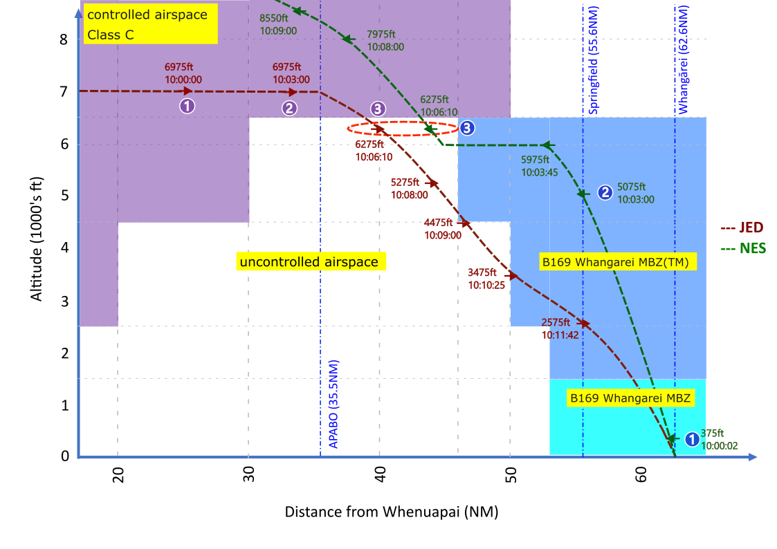
TAIC's Chief Commissioner David Clarke says the air proximity event involved a southbound Air New Zealand Q300 and a northbound Beech Duchess with the two planes heading toward each other on the same 20-nautical-mile route segment over the Bryndrwyn hills.
"The air traffic controller arranged for the two flights to pass each other in uncontrolled airspace, below the controlled space; this was in line with a then-common practice for this airspace," said Mr Clarke.
"Operating under Instrument Flight Rules in uncontrolled airspace, the pilots, not air traffic controllers, were responsible for avoiding each other, relying on radio calls to each other and on Air Traffic Control to provide information about other IFR traffic.
The TAIC report shows how the Q300 was level at about 6000 feet in cloud while the Beech descended through that same level in front of the Q300. As they closed in, the Q300 crew saw the Beech show up as a “conflict target’’ on their onboard airborne collision avoidance system. A Short-Term Conflict Alert triggered on the controller’s radar moments later, and the controller then cleared the Q300 to climb to 8000 feet.
The two aircraft passed at the same altitude at a combined closing speed of approximately 378 knots, with the Beech descending in front of the Q300, 4.3 nautical miles and 41 seconds apart at the closest point.
"There was no damage, nobody hurt, but it was too close. It happened because the controller or flight service officer hadn't provided sufficiently timely traffic information after sending both flights into uncontrolled airspace.
"This left each crew flying in cloud, unable to see the other plane, unaware of the immediacy of potential conflicts, and the crew of the Beech poorly placed to coordinate their own avoidance actions."
"The crews ended up in that risky situation due to long-standing weaknesses in the design of the Whangārei area airspace. Despite recurring concerns raised by pilots, controllers and the aerodrome operator, the North Sector airspace hasn't had a comprehensive review since 2014, even though reviews are required every five years."
"It's a nationwide issue because New Zealand needs there to be clear responsibility for conducting comprehensive airspace reviews.
The Commission has recommended the Civil Aviation Authority carry out a full review of lower-level airspace around Whangārei and act on the findings. It has also recommended the Ministry of Transport clarify which agency is responsible for ongoing nationwide airspace reviews and ensure they identify emerging risks before they lead to more serious events.