A passenger train collided with a truck, fatally injuring the truck driver. Truck had stopped but phone call distracted truck driver, who reduced pressure on brake and truck moved onto track. TAIC calls for formal determinations whether to implement level crossing safety recommendations; and a formal approach to prioritise upgrades for highest risk level crossings.
Executive summary Tuhinga whakarāpopoto

What happened
- At about 0730 on Monday 10 February 2020 a truck approached Mulcocks Road level crossing, in the Waimakariri District of Canterbury, heading towards State Highway 71.
- The flashing lights and bells at the level crossing were activated by the approaching Coastal Pacific passenger train.
- The truck slowed as it approached but did not completely stop short of the level crossing. Instead, the truck continued to move slowly forward onto the level crossing and into the path of the train.
- The train driver sounded the train’s horn upon realising the truck was not stopping.
- This alerted the truck driver but it was too late for them to take avoiding action.
- The train collided with the driver side of the truck’s cab. The truck driver was fatally injured in the collision.
Why it happened
- The truck driver had very likely recognised the activated flashing lights and bells and had intended to keep the truck stopped short of the level crossing until after the train had passed and it was safe to continue.
- The truck driver had very likely diverted their attention to some distraction inside the cab while believing the truck to be fully stopped. The truck driver was engaged in an incoming mobile phone call at this time, which may have contributed to them becoming distracted.
- The truck driver did not keep sufficient pressure on the brake pedal of the automatic-transmission truck, allowing the truck to slowly move forward.
- Closure of Mulcocks Road level crossing, recommended in a report (WDC Rangiora-to-Kaiapoi Cycleway LCSIA, Stantec NZ Ltd, July 2018) 18 months prior as a possible risk-reduction measure would virtually certainly have prevented this accident. Fitting half-arm barriers to Mulcocks Road level crossing, a secondary recommendation made in the same report, would very likely have prevented this accident. No formal assessment had been undertaken by Waimakariri District Council or KiwiRail to determine if these recommended measures were ‘reasonably practicable’ to implement, and no process or meaningful guidance existed for such an assessment. KiwiRail have since taken safety action to begin formalising a policy for this, and the Commission has made a recommendation for this policy to consider the most complete risk estimates available.
What we can learn
- Road users must avoid distractions and maintain awareness of their surroundings when approaching level crossings.
- The selection of level crossings for detailed risk assessment or upgrade does not reliably prioritise New Zealand’s highest risk level crossings. The Commission has made a recommendation that KiwiRail and Waka Kotahi NZ Transport Agency examine how Australasian level crossing assessment model (ALCAM) and other existing data sources can be utilised to better guide this selection.
Who may benefit
- Rail access providers, road controlling authorities, level crossing assessors and all other stakeholders for level crossing risk may benefit from the findings, safety issues and recommendations in this report.
- Investment decision-makers for roading and rail infrastructure may benefit from the findings, safety issues and recommendations in this report.
- Road users interacting with level crossings may benefit from the findings and key lessons in this report.
Factual information Pārongo pono
Narrative
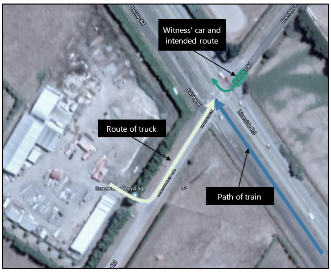
- At about 0730 on Monday 10 February 2020, the driver of a flatbed truck (the truck) departed from their workplace adjacent to Mulcocks Road level crossing (the level crossing) in Flaxton within the Waimakariri District of Canterbury. The truck turned left from the compound onto Mulcocks Road and approached the level crossing.
- At the same time the Coastal Pacific passenger train (the train) was approaching the level crossing northbound from Christchurch towards Picton carrying 98 passengers.
- Meanwhile a car was at the intersection of Bramleys Road and State Highway (SH) 71 Lineside Road, opposite the level crossing, waiting for a gap in traffic to allow it to turn right onto the northbound lane of SH71 Lineside Road. The car was directly opposite Mulcocks Road level crossing and its driver, who was the only identified witness to this accident (the witness), observed the truck’s approach.
- Mobile phone records showed the truck driver accepted an incoming call at 0730:50.
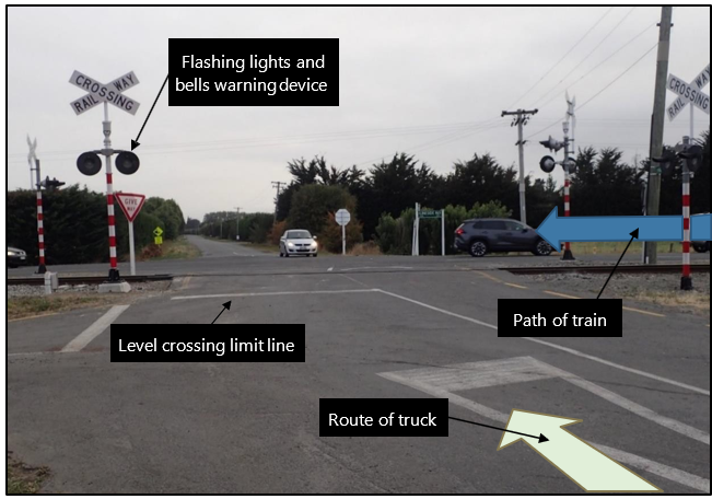
- The train activated the level crossing’s flashing lights and bells (see Figure 4) as it came within 535 metres of the level crossing, about 21 seconds before reaching it (based on an average speed of 90 kilometres per hour).
- The train driver observed the truck approaching the level crossing at a very slow speed and was confident that the truck was stopping. The train driver then turned their attention to road traffic travelling parallel to the train on SH71 Lineside Road that could potentially turn left onto Mulcocks Road and into the path of the train.
- The witness recalled observing the truck slow to a crawl as it approached the level crossing, but not coming to a complete stop. They also recalled observing the truck driver reaching down into the left-side passenger area, looking away from the approaching train.
- As the train approached the level crossing it was travelling at 92 kilometres per hour (based on data recovered from the locomotive’s onboard Tranzlog data recorder). The train driver realised the truck was advancing beyond the level crossing’s limit line and sounded the train’s horn about 75 metres, or 3 seconds, before the train reached the level crossing.
- The witness observed the truck driver look up and to their right to see the train approaching after its horn sounded. There was insufficient time for the truck driver to react and, at 0731:37, the train collided with the truck.
- The collision severed the train’s brake pipe and the sudden loss of air pressure automatically applied the train’s brakes to their maximum effort. The train came to a stop 509 metres past the point of collision.
- The truck was struck on the side of the driving cab. It spun anti-clockwise and overturned onto the driver side. The truck driver suffered fatal injury as a result of the collision.
- The train driver immediately contacted train control (the national train control centre housed in Wellington Railway Station where train movements and track occupations are authorised by train controllers) and requested the attendance of emergency services at the level crossing. The witness was the first to the truck and attempted to give first aid to the truck driver.
- There were no injuries sustained by the train’s crew or its passengers in the collision.
Personnel information
The truck driver
- The truck driver had worked adjacent to Mulcocks Road level crossing for approximately three years and was familiar with the level crossing.
- The truck driver held a standard Class 1 car licence, which was the appropriate licence for the truck.
- The truck driver had not worked the previous day, a Sunday, and had been at work for approximately 90 minutes before the collision.
- Post-accident toxicology results were negative.
The train driver
- The train driver had 36 years’ experience in their role and had current certification.
- The train driver’s roster did not indicate any areas of concern regarding fatigue.
- KiwiRail did not require train drivers involved in level-crossing accidents to be drug and alcohol tested.
Vehicle information
The truck
The truck was a 2011 Isuzu Elf. It had an automatic transmission, a twin-tyred rear axle (an axle featuring four tyres in total, with two tyres on each side, and able to carry greater axle loads than a single-tyred axle), and was approximately 6 metres long.
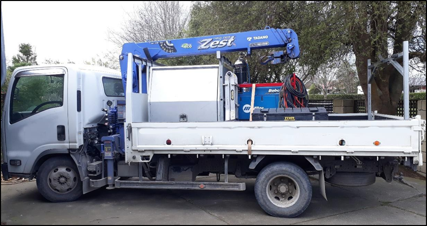
- On 3 February 2020, a week prior to the accident, the truck driver presented the truck for a Certificate of Fitness (CoF) inspection. The truck failed the inspection because three of the truck’s four rear tyres had a tread depth below the legal limit. These three tyres had not been replaced at the time of the accident. In all other aspects the CoF inspection found the truck to be in good working order, including its braking system.
- Post-accident, a New Zealand Police Commercial Vehicle Safety Team officer inspected the truck and found the brake linings to be in good condition, with no signs of excessive wear or damage.
- The truck’s dashboard was fitted with a magnetic mounting bracket that interfaced with a corresponding magnetic coupling on the protective case of the truck driver’s mobile phone. The driver’s mobile phone was found outside of the truck cab after the accident.
The train
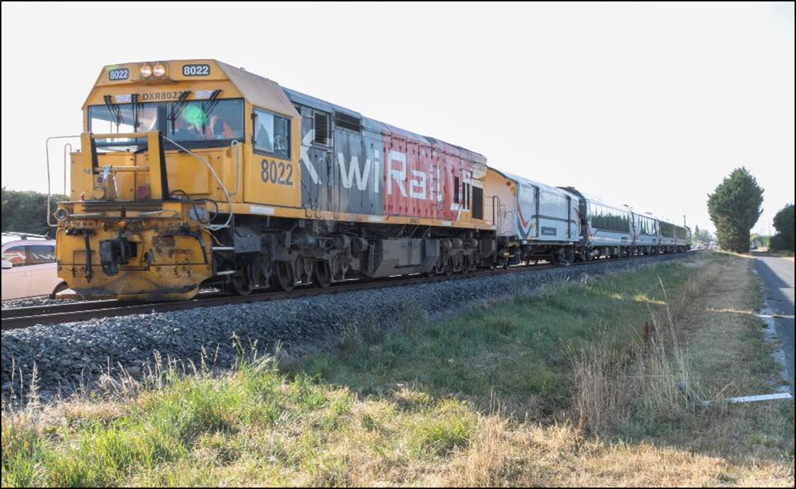
- The train was made up of the diesel-electric locomotive DXR8022 hauling an AKL luggage van, four AK class passenger carriages, and an AKV class combined generator van and observation car.
- The train was one of four scheduled trains to pass Mulcocks Road level crossing on the day of the accident. In February 2020, there were between two and six scheduled train movements per day (see Table 1 below). Work trains and non-train rail movements, such as track maintenance vehicles, would be additional to scheduled trains and vary day by day.

Meteorological information
- On the day of the accident the weather was fine, with little cloud and no rain.
- At the time of the accident the sun was rising just above the tree line on the opposite side of SH71 Lineside Road to the truck, approximately 8° above the horizon. The sun was positioned ahead and to the right in the truck driver’s field of view as they approached the level crossing, or approximately their 2 o’clock position (relative direction using a 12-hour clock face as viewed from directly above the truck where 12 o’clock is forward along the truck’s centreline).
Mulcocks Road level crossing
Layout and complexity
-
Mulcocks Road level crossing is adjacent to a cycleway and a no-exit residents’ access road (Paisley Road) on its south-western side, and to SH71 Lineside Road on its north-eastern side (see Figure 6 below).
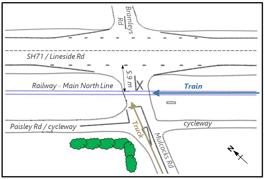
- There is limited stacking distance on the north-eastern side of Mulcocks Road level crossing, with only 5.9 metres between the centre of the rail tracks and the edge of SH71.
- The road rises on both approaches to the level crossing, making it difficult for road users to assess the available stacking distance before they commit to traversing the level crossing.
-
There are no deceleration or acceleration slip roads off or on to SH71 Lineside Road for negotiating the turn, both for:
north-west bound road traffic on SH71 entering Mulcocks Road
left-turning road traffic exiting Mulcocks Road to join SH71 Lineside Road.
- There is no turning bay for south-east bound road traffic on SH71 Lineside Road turning right into Mulcocks Road.
Protection
- Mulcocks Road level crossing was protected by flashing lights and bells, activated by a track circuit 535 metres before the level crossing.
- The witness recalled seeing the flashing lights on the SH71 Lineside Road side of the level crossing operating shortly before and then during the collision. They also recalled hearing the bells sounding in the immediate period following the accident.
- KiwiRail’s attending Rail Incident Coordinator (RIC) confirmed the bells were sounding when they arrived at the scene at about 0809. The bells were later shut off by a KiwiRail signalling technician.
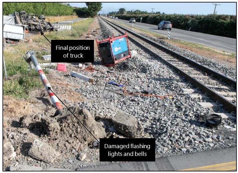
- The flashing lights and bells that faced the truck as it approached the level crossing were heavily damaged in the collision (see Figure 7).
Mulcocks Road level crossing jurisdiction and responsibility
- Responsibility for level crossings is complex in that it overlaps amongst rail access providers and road controlling authorities (RCAs).
- Mulcocks Road level crossing’s proximity to SH71 Lineside Road means there are three agencies with maintenance interests (as defined in Traffic Control Devices Manual Part 9 Level Crossings, Waka Kotahi New Zealand Transport Agency, Second Edition amendment, 1 December 2012):
- KiwiRail, as the rail access provider, is responsible for the formation and maintenance of the road surface 5 metres either side of the centre line of the railway line. They are also responsible for the maintenance of flashing lights and bells and any other active protection (includes all level crossing warning devices that are activated by an approaching train, including flashing lights, bells and barriers. It is contrasted by passive protection, which warns users of a level crossing, but does not alter this warning when a train is approaching) systems.
- Waimakariri District Council (the Council) is the RCA for the district and is responsible for all local roads, excluding private and state highways. The Council is responsible for the formation and maintenance of the road surface beyond 5 metres either side of the railway centreline and all associated pavement marking related to the level crossing, regardless of the 5-metre distance.
- Waka Kotahi NZ Transport Agency (Waka Kotahi) is the RCA for all state highways in New Zealand and is responsible for their maintenance.
Risk assessment for Mulcocks Road level crossing
- An overview of the processes used to assess and manage level crossing risk in New Zealand is included as Appendix 1 of this report. This section provides factual information for risk assessment activities undertaken for Mulcocks Road level crossing prior to the accident.
- In 2016 and 2017, the Council constructed the Rangiora-to-Kaiapoi cycleway, parts of which run alongside the Main North Line railway. This cycleway crossed both Mulcocks Road and nearby Fernside Road alongside each road’s level crossing.
- In 2017, after the cycleway was completed, KiwiRail’s Project Management Office requested that the Council conduct a level crossing safety impact assessment (LCSIA) for both Mulcocks Road and Fernside Road level crossings.
- The requested LCSIAs were conducted by Stantec and a combined report (WDC Rangiora-to-Kaiapoi Cycleway LCSIA, Stantec NZ Ltd, July 2018) was delivered to the Council in July 2018.
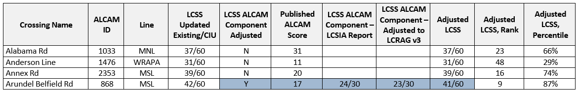
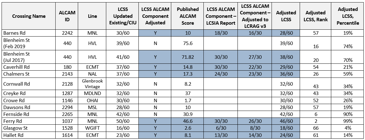
- At this time Mulcocks Road level crossing had a published Australasian level crossing assessment model (ALCAM) risk score of 24.1 (erroneously recorded as 30.9 in the LCSIA report. Accounts for updated 2018 annual average daily traffic estimates, but otherwise it was the known ALCAM risk score prior to Stantec’s LCSIA being undertaken). This equates to an estimated annual probability of 0.241per cent for an equivalent fatality (a unit that ALCAM uses for injury equivalence, defined as 1 fatality, 10 major injuries or 200 minor injuries), or an estimated 415 years between equivalent fatalities.
- Mulcocks Road level crossing’s ALCAM risk score was the 260th greatest amongst New Zealand’s roadway level crossings. This put it in the ‘high risk’ band for ALCAM’s New Zealand jurisdiction (ALCAM groups level crossings into separate jurisdictions for Australian states and territories and New Zealand. Level crossings within each jurisdiction are then evenly distributed into five ALCAM risk bands based on their ALCAM risk score) – meaning it was inside the top 20 per cent of level crossings for ALCAM risk score.
- The LCSIA report determined Mulcocks Road level crossing, in its existing state, to have a level crossing safety score (LCSS) (an out-of-60 score that reflects the risk associated with a level crossing, with 60/60 being the greatest possible risk. Incorporates ALCAM risk scores with other more subjective risk estimation methods) of 43/60.
- The LCSIA report considered the following risk treatments, as identified by the safety review team undertaking the assessment.
- Installation of half-arm barriers.
- Installation of short-stacking (a hazard condition that exists when stacking distance is limited) warning signage for road users.
- Installation of level crossing signage on cycling routes.
- Installation of flashing lights and bells to face the south side of the cycleway.
- Signage and pavement marking to be installed or reinstated.
- Road surface improvements or repairs.
- Installation of whistle boards to ensure approaching trains sound their horns.
- The report concluded that these treatments would lower Mulcocks Road level crossing’s LCSS to 31/60. This did not meet the LCSIA process’ preferred ‘Criterion 1’ (the LCSIA process practical equivalent to a broadly acceptable risk. Appendix 1 contains further detail of the LCSIA process and the criteria it uses), but did meet ‘Criterion 2’ (the LCSIA process practical equivalent to a tolerable risk. It aims to ensure risk is not increased from its existing level and is reduced wherever practicable) by lowering the LCSS from its existing value.
- For ‘Criterion 1’ the report recommended, ‘if reasonably practicable’, to close the level crossing. The report reasoned that, given the low traffic volumes on Mulcocks Road and the alternative routes available, it was not expected that many road users would be adversely affected by closing the level crossing and Mulcocks Road’s exit onto SH71 Lineside Road.
- The LCSIA process required that closure of the level crossing be assessed first for ‘so far as is reasonably practicable’ (SFAIRP) (a risk management principle that requires control measures be taken wherever practicable, while allowing for measures to not be taken where it can be demonstrated that the cost, resources or effort required to implement a measure outweigh the benefit they provide. See Appendix 10 for a detailed explanation of the SFAIRP principle and related risk management concepts). If closure was found not reasonably practicable then half-arm barriers and other risk treatments per 2.47 were next required to be SFAIRP-assessed.
- The LCSIA report and its recommendations were discussed between the Council and KiwiRail. No formal SFAIRP assessment was undertaken and no documented record of discussions was made, but the following consideration was given to each of the recommended risk treatments.
-
Closure was identified by the Council as challenging due to Mulcocks Road providing a detour route during periods of closure for SH71 Lineside Road, including when road accidents occur.
-
Installation of half-arm barriers did not proceed because of Mulcocks Road level crossing not being inside KiwiRail’s ‘Top 200’ list of ALCAM risk scores.
- Waka Kotahi, as the RCA for SH71 Lineside Road, would have needed to be consulted on Mulcocks Road level crossing’s closure. However, they were not otherwise responsible for the level crossing and were not included in discussing the LCSIA report or its recommendations.
Analysis Tātaritanga
Introduction
- A collision between a large road vehicle and a passenger train travelling at 90 kilometres per hour is a serious incident with potentially serious consequences. It has the potential to derail the train, injure persons and cause significant damage to equipment.
- There are approximately 1500 public level crossings throughout New Zealand. Except for rail passengers at platforms and onboard trains, these level crossing sites account for the vast bulk of instances where members of the public enter the rail corridor and are consequently put at risk. Considerable effort has been made to improve protection at level crossings, which has required substantial resources and funding. Despite these ongoing safety improvements, level crossings remain a significant risk and one that can be expected to grow with increasing road and rail traffic.
- The Commission’s analysis for this accident examines its immediate causes and circumstances. It also examines the wider issues surrounding risk assessment and risk management for level crossings, of relevance due to Mulcocks Road level crossing being one of a limited number to have undergone assessment under the recently-developed LCSIA process.
Distracted driving
- The Commission determined the flashing lights and bells were virtually certain to have been working correctly at the time the truck approached the level crossing. The witness’ account of seeing the flashing lights, and the RIC’s account of the flashing lights and bells still being active when they attended the site, both support this.
- Separate independent accounts from the witness and the train driver observed the truck slowing significantly before it reached the level crossing. The Commission have therefore found it very likely that its driver recognised and reacted to the active flashing lights and bells, intending to stop the truck before the level crossing and then remain stopped until after the train had passed.
- The truck’s slow forward crawl towards the level crossing in the lead-up to the collision was very likely due to its driver not applying sufficient pressure to the brake pedal. Other explanations for this forward crawl, such as mechanical failure of the truck’s braking system or the driver’s foot slipping completely from the brake pedal, were considered in the Commission’s analysis. These were eventually discounted because no such issues were noted in the truck’s pre-accident or post-accident inspections and there were no witness accounts of any apparent attempt by its driver to react to such a failure or error.
- The Commission found no evidence of the truck losing traction with the road surface prior to the collision, and it is therefore exceptionally unlikely that the low tread on three of the truck’s four rear tyres contributed to this accident in any way.
- It is very likely that the truck driver’s peripheral vision cues outside of the cab were restricted and as a result they were unable to detect the truck’s subtle forward movement. This assessment is based on the truck’s slow forward crawl itself and the witness’ observation of its driver looking down towards, and reaching with their left arm into, the passenger side area. It is very likely the truck driver believed the truck to be stationary and felt it safe to divert their attention from the truck’s surroundings.
- The Commission was unable to determine the precise source of the distraction that caused the truck’s driver to divert their attention away from the truck’s surroundings.
- New Zealand law prohibits the use of mobile phones while driving road vehicles. An exception to this is that a driver may, while driving a vehicle, use a mobile phone for telephone calls if:
- the phone is secured in a mounting fixed to the vehicle
-
the driver manipulates the phone infrequently and briefly.
- The Commission was unable to determine if the truck driver was utilising the hands-free mounting fitted to the truck dashboard at the time of the accident. The magnetic coupling between their mobile phone and the mounting is exceptionally unlikely to have withstood the collision forces, so no conclusion can be made from the mobile phone being found outside the truck’s cab.
- The truck driver being engaged in a mobile phone call does not itself explain why their visual attention was not on the truck’s surroundings, but still likely contributed to their overall level of distraction and lack of situational awareness.
- The position of the sun in relation to the truck driver’s field of vision would have increased the difficulty for them to see the approaching train. However, as established above, it is very unlikely that the truck driver’s visual focus was towards the approaching train. Sun-strike itself is therefore judged very unlikely to have significantly contributed to this accident, but may have further limited the peripheral vision cues available to the truck driver.
Mulcocks Road LCSIA report and action taken
Safety issue: SFAIRP assessments were not being routinely carried out for risk treatments recommended in LCSIA reports. No process, and minimal guidance, on SFAIRP assessment for level crossing risk treatments was available in industry documents.
Crossing closure
- The LCSIA report’s recommended ‘Criterion 1’ risk treatment, closure of Mulcocks Road level crossing, would virtually certainly have prevented this accident.
- The LCSIA process requires ‘Criterion 1’ risk treatments be given first consideration. Its guidance documentation provides a flowchart, an excerpt of which is shown in Figure 8 below. The path overlaid in green shows the process that crossing closure should have followed, arriving at ’Is treatment suitable given constraints?’ This step represents a joint SFAIRP assessment between KiwiRail and the Council.
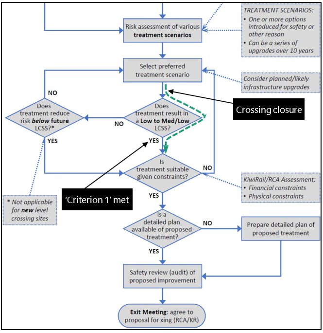
- Neither the Council nor KiwiRail could provide a documented SFAIRP assessment for the LCSIA report’s recommendation to close Mulcocks Road level crossing. Such an assessment – if it had occurred – may legitimately have concluded crossing closure as being not reasonably practicable, but this was not formally conducted or documented.
Installation of half-arm barriers
- Amongst the LCSIA report’s recommended ‘Criterion 2’ risk treatments was the installation of half-arm barriers, which would very likely have prevented this accident either by:
- the truck driver becoming alert to the truck’s movement, by sound or feel, when it struck the barrier arm
- the barrier arm physically preventing the truck from crawling forwards.
- The LCSIA process requires ‘Criterion 2’ risk treatments be considered if ‘Criterion 1’ is not reasonably practicable. Figure 9 again shows the guidance documentation flowchart, but with the path overlaid in green representing consideration of half-arm barriers if crossing closure was determined to not be reasonably practicable. Again, this arrives at a joint SFAIRP assessment between the Council and KiwiRail.
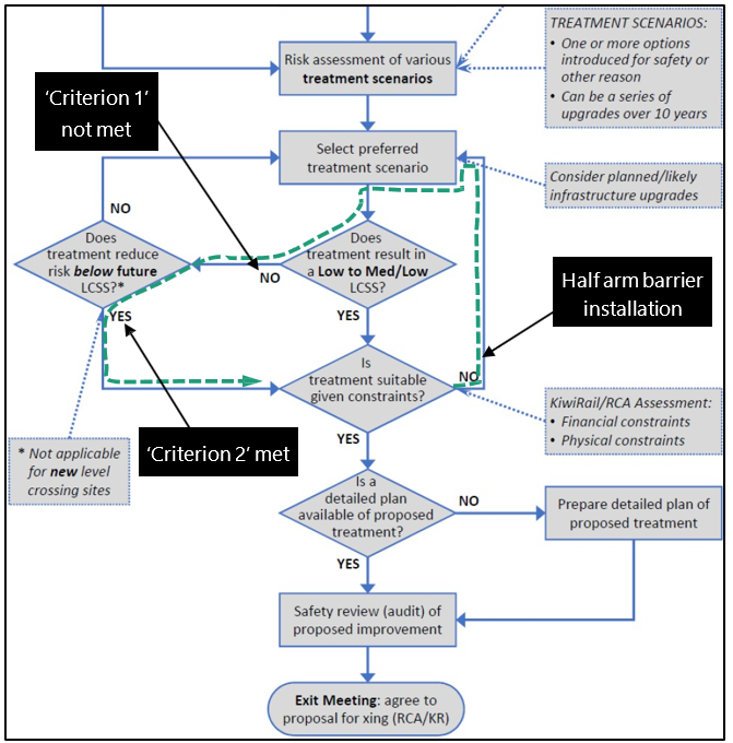
- As with crossing closure, no documented SFAIRP assessment for the installation of half-arm barriers could be provided by the Council or KiwiRail. Such an assessment – if it had occurred – may have legitimately concluded half-arm barriers to not be reasonably practicable, but this was not formally conducted or documented.
- Importantly, issues of short-stacking at Mulcocks Road level crossing would not have been addressed by half-arm barriers. Short-stacking was a significant factor in the estimated risk for the level crossing, so despite not contributing to this accident this decreases the likelihood that half-arm barriers would have been found practicable in a SFAIRP assessment.
Other recommended risk treatments
- Other ‘Criterion 2’ risk treatments recommended in the LCSIA report (see 2.47 for full list) are very unlikely to have prevented this accident. These treatments were predominantly aimed at unfamiliar road users recognising the level crossing, or at cyclists using the new cycleway.
- As with crossing closure and half-arm barriers, no documented SFAIRP assessment could be provided by the Council or KiwiRail for these other recommended risk treatments.
Formal SFAIRP assessment
- KiwiRail responded to the Commission’s questions on SFAIRP assessment for LCSIA recommendations, stating that no formal policy or process existed at the time Mulcocks Road level crossing’s LCSIA report was published or at the time of the accident.
- Recommended risk treatments made in LCSIA reports for other level crossings throughout New Zealand have similarly not been formally SFAIRP-assessed, although many have been implemented.
- Amongst other documents available to industry there are references to SFAIRP assessment for identified level crossing risk treatments. Included in these is Waka Kotahi’s Traffic control devices manual (TCDM) Part 9 for level crossings. However, no process or guidance on how to undertake a SFAIRP assessment for level crossings is provided in these documents.
Context for Mulcocks Road level crossing LCSIA
Safety issue: Level crossing safety scores (LCSS) have little influence on the prioritisation of level crossing upgrades.
- The Commission has undertaken a review of other available LCSIA reports to gain perspective on Mulcocks Road level crossing’s ‘updated existing’ LCSS value of 43/60 relative to others throughout New Zealand.
- Around 200 LCSIAs (LCSIAs in this context are determined as a set of LCSS scores and recommendations for an individual road or pedestrian crossing. In many cases, a single LCSIA report will include several LCSIAs for either different level crossings or separate roadway/pedestrian crossings at the same location) were made available to the Commission by KiwiRail, who review and approve all reports before they are published. Of these, 70 were selected as suitable for comparison with Mulcocks Road level crossing. These are presented in Appendix 2, along with the rationale for their selection.
- LCSS values were taken from these comparable LCSIAs and adjusted to reflect the most up-to-date methodology for converting ALCAM risk scores to LCSS values (Appendix 2 details these adjustments). This aimed to achieve as close to a like-for-like comparison as possible.
- Adjusted LCSS values were compared across all 70 selected LCSIAs. The overall distribution – and Mulcocks Road level crossing’s position within it – are presented in Figure 10 below, along with LCSIA risk bands (these risk bands classify risk based on LCSS intervals of 10. See Appendix 1 for further explanation).
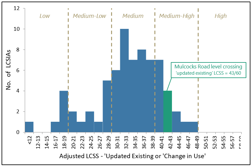
- This puts Mulcocks Road level crossing in the 94th percentile, or fifth-ranked overall, for LCSIA-estimated risk amongst this sample group.
- This position demonstrates how Mulcocks Road level crossing, despite its ALCAM risk score and being outside KiwiRail’s ‘Top 200’ ALCAM list, was identified by the LCSIA process as comparatively high risk.
- Even if Mulcocks Road level crossing had been assessed at its maximum possible ‘updated existing’ LCSS of 55/60 (based on 25/30 for Mulcocks Road level crossing’s ALCAM risk score of 24.1 and then 10/10 for each of the three other risk-estimation components. Appendix 1 explains the composition of LCSS values), this would not have affected the risk treatments recommended in its LCSIA or their evaluation against ‘Criteria 1 and 2’. Crossing closure would still have been the ‘Criterion 1’ recommended risk treatment and half-arm barriers etc would still have satisfied ‘Criterion 2’.
- It is then also very unlikely that an LCSS of 55/60 would have influenced the Council and KiwiRail’s informal SFAIRP assessments. The Council’s assessment of crossing closure impracticability did not take account of raw LCSS values, and Mulcocks Road level crossing’s position outside KiwiRail’s ‘Top 200’ ALCAM list was the predominating factor in half-arm barriers being assessed as not practicable.
Regular risk review LCSIAs
Safety issue: Selection of level crossings for regular risk review LCSIAs, and often upgrade, is not being effectively prioritised towards those with greatest estimated risk.
- Level crossing safety assessment and upgrade should be prioritised to select level crossings with the greatest associated risk. This is especially true where available funding and resources for upgrades is constrained.
- Prioritised selection of level crossings was not a contributing factor in this accident. Mulcocks Road level crossing underwent its LCSIA due to a ‘change in use’ (the construction of the cycleway) and other risk indicators, such as its ALCAM risk score, did not identify it as especially high risk.
- ‘Regular risk review’ LCSIAs are those carried out to assess existing risk of a level crossing. This is where the opportunity exists to selectively prioritise level crossings for detailed risk estimation under the LCSIA process, rather than the essentially random selection for ‘change in use’.
- The Commission’s review of comparable LCSIAs identified 20 of the 70 as being undertaken for ‘regular risk review’. The remainder were all ‘change in use’.
- Figure 11 below shows the ALCAM fatal return period (the fatal return period is ALCAM’s estimated number of years between equivalent fatalities (see footnote 16). It is the inverse of the ALCAM risk score (see Appendix 1 for further explanation). against the adjusted ‘updated existing’ LCSS for these 20 ‘regular risk review’ LCSIAs. In each case the ALCAM data was known prior to the LCSIA being undertaken, while the LCSS was only known afterwards. Mulcocks Road level crossing’s LCSIA, undertaken for ‘change in use’, is also included for its context.
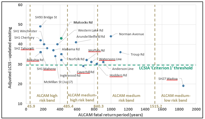
- Figure 11 indicates where selection for ‘regular risk review’ LCSIAs has not been effectively prioritised by ALCAM data. 45 per cent are outside of ALCAM’s ‘high risk’ band and 55 per cent have a longer ALCAM fatal return period than Mulcocks Road level crossing. A rigorous ALCAM-based prioritisation would instead show data points tightly grouped towards the left side of the ‘high risk’ band.
- Any alternative prioritisation could be demonstrated as effective by its resultant LCSS values. That is, undertaking LCSIAs – and upgrades – for level crossings with low ALCAM risk scores could be justified if the LCSIA process then identified these as being high risk. With some exceptions, most notably Norman Avenue, this is not apparent in Figure 11.
- In the example of SH27 Waitoa, which was upgraded to half-arm barriers, the LCSIA process in fact found this level crossing in its existing state to meet ‘Criteria 1’ and therefore to be a ‘broadly acceptable risk’ (where a risk is judged as low enough to not warrant consideration of further reduction or mitigation. Not generally considered a fixed threshold, it differs between different industries and activities, and shifts with changes in societal attitudes towards risk. See Appendix 2 for further explanation of this concept). This demonstrates where level crossing upgrade resources are being consumed by a level crossing with low relative risk.
- The selection rationale for ‘regular risk review’ LCSIAs, and indeed upgrades in many cases, was not clearly stated in most reports. Instead, many (Alabama Road, Arundel Belfield Road, Caverhill Road, Inglewood Road, McMillan Street (July 2017 LCSIA), Rukuhia Road, SH1 Chertsey, SH1 Maheno, SH1 Winchester, SH2 Tahoraiti and SH93 Bridge Street) simply included ’KiwiRail are planning to construct half-arm barriers…’ or similar statements, with no elaboration on why a particular level crossing had been selected.
- Equally, several level crossings in the Wairarapa region (Anderson Line, Hodders Road, Moffats Road, Norfolk Road, Norman Avenue, Watersons Line and Western Lake Road) were grouped into one report for their geographical proximity. No upgrade proposals were in place at this time, and instead the report was aimed at scoping suitable proposals. This approach will have benefited from a lower per-level crossing cost to conduct LCSIAs.
- In the broader context, New Zealand’s greatest ALCAM risk score was 218 (as of 30 July 2020. This is the same dataset used in LCRAG v3), equating to a 46-year fatal return period. The greatest ALCAM risk score amongst the 20 ‘regular risk review’ LCSIAs was only 59.0 for SH93 Bridge Street (equating to a 169-year fatal return period).
- Figure 12 below shows this shortfall between level crossings with the greatest ALCAM risk scores and those that have been selected for ‘regular risk review’ LCSIAs.
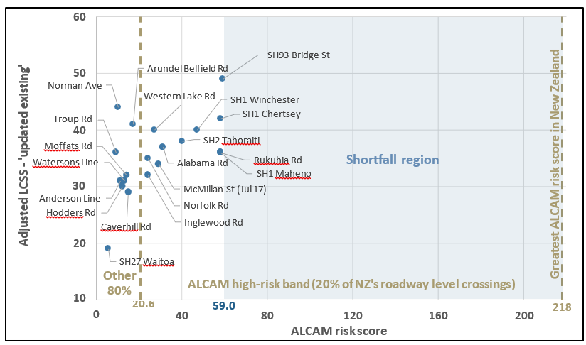
- Figure 12 indicates that level crossings identified using ALCAM’s estimate as having the greatest risks are not being prioritised for ‘regular risk review’ LCSIAs and action.
Band thresholds for ALCAM to LCSS conversion
- The Commission’s analysis noted the 20.6 threshold between ALCAM ‘medium-high’ and ‘high’ risk bands in the LCSIA guidance document (LCRAG v3 from November 2020. Version 4 has since been published in March 2021, but has this same issue) is ambiguous.
- Ambiguity arises because the overlap in ‘ALCAM Risk Score’ ranges ’19-20’ and ’20-40’ is 19.5 – 20.49, and the ‘Threshold’ value of 20.6 is outside of this overlap.
- For example, an ALCAM risk score of 20.55 would be outside the ’19-20’ range, but still below the 20.6 threshold, making it unclear whether to assign an LCSS of 24/30 or 25/30.
- ‘ALCAM Risk Score’ ranges of ‘19-21’ and ’21-40’ would shift the overlap and remove this ambiguity.
- This is expected to have had negligible impact on LCSIAs completed to date, but has the potential to produce misleading LCSS values in future.
Appendix 1. Level crossing risk management in New Zealand
Level crossing risk
The typically high masses and long stopping distances associated with trains and other rail vehicles mean that level crossing collisions have serious ramifications, and that their avoidance is heavily reliant on the road traffic and pedestrians using a level crossing.
This, combined with level crossing collisions being relatively low likelihood events, creates challenges both in the assessment of risk for individual level crossings and in the optimisation of overall risk reduction with available resources.
Level crossings, and the risk they pose, can be eliminated by grade separation (to isolate road and rail traffic from one another by the construction of a bridge or tunnel/underpass). However, this is typically expensive to undertake and in some cases is impracticable due to physical constraints (adjacent landowners and infrastructure etc).
Closure of level crossings similarly eliminates their risk, but is also impracticable in many cases because of the need for people, vehicles and livestock to cross railways.
Level crossings consequently remain a feature of New Zealand’s rail network and of many others throughout the world.
Accepting the existence of level crossings, their available risk controls then fall into two categories.
- Active protection – where the approach of rail vehicles automatically activates warning devices, such as flashing lights and bells, or deploys physical barriers.
- Passive protection – warns users of a level crossing’s presence by signage and other means, but does not react to approaching rail vehicles, and instead relies on level crossing users to check for trains before traversing.
Active protection provides greater risk mitigation than passive protection but has greater associated cost. Level crossings with greater traffic volumes, poor sighting distances (the distance from a level crossing where an approaching train becomes visible. It may be limited by factors such as obstructions or track curvature) or other risk-increasing factors are more likely to have active protection systems.
So far as is reasonably practicable
The Railways Act 2005 requires rail participants to ensure that, ‘so far as is reasonably possible’ (SFAIRP), its activities do not cause the death of, or serious injury to, individuals.
A similar concept to managing risk SFAIRP is reducing risk to ‘as low as reasonably possible’ (ALARP). The ALARP principle has its origins in United Kingdom health and safety law, but is in widespread use throughout numerous industries and countries.
The ‘ALARP Triangle’ is a visual model that explains the principle. The figure below shows it as it is included in New Zealand’s NRSS/4 (National Rail System Standard/4, Risk Management, Issue 2, Effective Date: 11 June 2007).

The ‘Intolerable region’ in the ALARP Triangle is where a risk is judged too great to be accepted. In the context of level crossings this is where collision risk is assessed as being too great for a level crossing to remain open.
The ‘ALARP or Tolerable Region’ indicates where a risk must be assessed against the availability and suitability of ways to eliminate or minimise risk (viable solutions), and the proportionality of associated costs (cost of viable solutions). For a level crossing this means identifying available protections, and then weighing the benefit of these protections against the cost and resources required to implement them. Protections can then be assessed as not reasonably practicable if cost and resources outweigh the benefit. Often organisations will apply some factor to this weighing, such as the cost and resources needing to exceed twice (or some other multiple) the estimated benefit.
The ‘Broadly acceptable region’ is where the associated risk is below a threshold level that no further weighing of cost-benefit for further protection is necessary.
Some debate exists on the interchangeability of SFAIRP and ALARP in risk management. Commonly (NZ Transport Agency research report 632 ‘Framework for review and prioritisation of rail safety risks in New Zealand’, December 2017, Navigatus Consulting), the distinction made between the two is that the SFAIRP concept does not have a ‘Broadly acceptable region’, and that weighing of cost-benefit should be undertaken for all viable solutions irrespective of the risk level. For the purposes of this report, both are considered interchangeable and the ‘Broadly acceptable region’ is considered to exist.
Level crossing risk assessment tools in New Zealand
Australian level crossings assessment model (ALCAM)
ALCAM is an assessment tool first concepted in Queensland in 1999 and then adopted throughout Australia in 2003.
KiwiRail and Waka Kotahi undertook an extensive survey to collect ALCAM data for public level crossings in 2008-2012. It has since become an embedded part of New Zealand’s management of level crossing risk.
ALCAM applies separate models for roadway crossings and pedestrian crossings.
ALCAM scores roadway level crossings for safety risk according to an extensive range of factors, including level crossing characteristics, visibility, controls and protections, volumes and types of road/pedestrian/rail traffic, train and road vehicle speeds, and nearby rail and roading infrastructure.
ALCAM computes a risk score for roadway level crossings that is equivalent to the estimated annual probability of one equivalent fatality occurring, expressed as a decimal. ALCAM risk scores can be up to 16 decimal places, and so common reporting practice is to multiply them by 10,000 and then round to either a whole number or 1 decimal place.
The inverse of the ALCAM risk score can be used to express the estimated number of years between equivalent fatalities. This is termed the ‘fatal return rate’.
ALCAM risk scores are available for all level crossings throughout New Zealand. However, there is an ongoing, resource-intensive need to maintain input data (average user volumes etc) meaning that the up-to-datedness of these risk scores can vary significantly.
ALCAM categorises level crossings into five risk bands (high, medium-high, medium, medium-low and low) based upon their risk score relative to all others within the same jurisdiction (ALCAM jurisdictions group level crossings by the entities responsible for their associated risk. New Zealand is its own jurisdiction within ALCAM, as typically are Australian states and territories), with each band always containing 20 per cent of a jurisdiction’s level crossings. This even distribution means that the thresholds between bands shift over time as risk scores amongst a jurisdiction’s level crossings evolve.
A global risk banding is also available in ALCAM, which uses the combined data of all jurisdictions’ level crossings. However, this has limited applications within level crossing risk management in New Zealand.
While ALCAM is a comprehensive tool for assessing level crossing risk, its overseeing committee acknowledge it is unsuitable for isolated application. It is not able to fully account for factors such as local knowledge, incident history and engineering judgement, and so instead it is only intended for use in support of wider decision-making processes.
Importantly, ALCAM does not attempt to set a risk threshold for mandated level crossing upgrade. Nor does it attempt to define a threshold for a ‘safe’, or acceptable, level of level crossing risk. That is, it does not define a boundary between the ‘Intolerable’, ‘ALARP or Tolerable’ and the ‘Broadly acceptable’ regions depicted in the ALARP Triangle.
Instead, ALCAM leaves these decisions for each jurisdiction’s risk owners. This depends on wider considerations such as the level of risk at other level crossings within a jurisdiction, what risk levels owners are prepared to tolerate, and the availability of funding and resources for risk reduction.
Level Crossing Safety Impact Assessment (LCSIA)
To further support decision-making, a Level Crossing Risk Assessment Guidance (LCRAG) document was developed for KiwiRail and Waka Kotahi. It was first published in July 2017 and has since been updated in October 2018, November 2020 and March 2021.
The document defines the methodology for conducting a Level Crossing Safety Impact Assessment (LCSIA) and details how to calculate a Level Crossing Safety Score (LCSS).
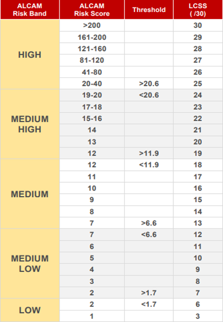
The LCSS value is an out-of-60 score that represents the estimated risk for a level crossing. It incorporates a converted ALCAM risk score (30 available points), but also considers three wider factors, each comprising 10 available points.
- Crash and incident history.
- Site survey observations.
- An engineers’ assessment (combined train driver and roading engineer).
LCSS values are then used to classify level crossings into five risk bands, as shown below.
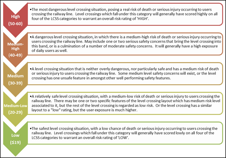
LCSS risk bands differ significantly from ALCAM risk bands. The boundaries are fixed at
10-point intervals and there is no forced distribution applied (like in ALCAM’s approach to fit 20 per cent of level crossings within each band). This means, for example, a level crossing may have a ‘medium’ ALCAM risk banding, but a ‘medium-high’ LCSS risk banding.
LCSIAs must be undertaken for all new level crossings and for ‘change in use’ of existing level crossings. A change in use is anything with the potential to materially affect a crossing’s risk profile, including changes to the level crossing design, to nearby infrastructure or in user volumes (road, pedestrian and rail). It is the responsibility of the change’s proposer to have the LCSIA undertaken by a KiwiRail-accredited LCSIA assessor.
For a typical LCSIA, some or all the following stages will have an LCSS value calculated.
- ‘Updated Existing’ – risk for a level crossing as it currently exists, accounting for current-day user volumes.
- ‘Change in Use’ – risk for the level crossing if a given change (eg, new cycleway constructed adjacent) is made in its as-proposed state.
- ‘Proposed Design’ – risk for a crossing with the change made and at-grade risk treatments (refers to risk mitigation measures that can be applied to a level crossing while the roadway and railway remain at the same level. Contrasts with grade separation, where a railway crossing ceases to be a level crossing, and with closure where it ceases being a railway crossing) applied as recommended by the safety review team (eg, installing flashing lights and bells, improvements to warning signage etc).
- ‘Future Score’ – risk for the crossing under the ‘Proposed Design’, but accounting for expected user volume increase over a period of 10 years.
The LCSIA then has two criteria for a level crossing’s design or upgrade.
- ‘Criterion 1’ – the ‘Proposed Design’ and ‘Future Score’ are brought within low or medium-low LCSS risk bands (LCSS is 29 or less).
- ‘Criterion 2’ – the ‘Proposed Design’ and ‘Future Score’ achieve an LCSS less than or equal to the ‘Updated Existing’ value.
‘Criterion 1’ is the effective equivalent of the ‘Broadly acceptable region’ in the ALARP Triangle and is the LCSIA methodology concluding a risk warrants no further mitigation. This is a mandatory requirement for new level crossings.
For existing level crossings undergoing a change, ‘Criterion 1’ is preferred, but does not need to be met if the solution can be demonstrated as exceeding SFAIRP limits (cost or other constraints). This is equivalent to the ‘ALARP or Tolerable Region’ in the ALARP Triangle.
Similarly, individual ‘Criterion 2’ risk treatment recommendations (potential upgrades) identified in an LCSIA do not have to be applied if it can be demonstrated they exceed SFAIRP limits. ‘Criterion 2’ must however still be met overall, or the change must not proceed.
The effect of these two criteria and the LCSIA process overall mean that:
- new level crossings must not exceed ‘broadly acceptable’ risk
- changes to existing level crossings must not increase risk beyond its existing level
- changes to existing level crossings must reduce risk to ‘broadly acceptable’ levels, unless it can be demonstrated this is not reasonably practicable.
The LCSIA process is also used to assess existing level crossings not undergoing a change in use. These assessments generally aim to better understand existing level crossing risk on New Zealand’s railway network or to inform design for proposed level crossing upgrades. As with ‘change in use’ assessments, ‘Criterion 1’ is preferred but not mandated for these.
Appendix 2. Summary of reviewed LCSIAs
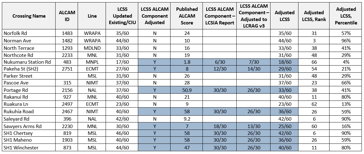
The following table lists the LCSIAs that were selected as comparable to Mulcocks Road level crossing for the Commission’s review.
Selection was based on roadway level crossings for public roads, or private roads with significant road vehicle volumes. Private level crossings with low user volumes were not included.
In a small number of instances two separate LCSIAs are available for a single level crossing, indicating that it has been assessed twice. In these cases, both LCSIAs are included and are denoted in the ‘Crossing name’ column by their assessment year.
Early LCSIAs, where LCSS values were not explicitly calculated, were excluded because no numerical comparison could be made.
‘Change in use’ LCSS values were extracted from each LCSIA, or where these were not available ‘Updated Existing’ LCSS values were extracted instead. This ensured the greater LCSS values from each LCSIA were used and there was a fair comparison to Mulcocks Road level crossing’s ‘Updated Existing’ value (but is representative of ‘Change in use’ because the LCSIA was conducted after the construction of an adjacent cycleway).
LCSIAs conducted before, and for a short crossover period following, the publication of Level Crossing Risk Assessment Guidance (LCRAG) v1 in July 2017 used a more basic methodology for converting ALCAM risk scores to LCSS ALCAM Component values. This was based solely on ALCAM risk bands and meant all values were in increments of six. This difference in methodologies limits the comparability of LCSIAs, and so LCSS values for all LCSIAs have been adjusted according to the LCRAG v3 methodology.
- Alabama Road LCSIA, MWH/Stantec NZ Ltd, 21 July 2017.
- Wairarapa LCSIA, Stantec NZ Ltd, 2 March 2018.
- Annex Road LCSIA, MWH/Stantec NZ Ltd, 8 December 2017.
- Arundel Belfield Road LCSIA, MWH/Stantec NZ Ltd, 17 June 2017.
- Northern Line MCR LCSIA, MWH/Stantec NZ Ltd, 5 July 2017.
- Trentham to Upper Hutt Double Tracking LCSIA, Stantec NZ Ltd, February 2019.
- Upper Hutt City Council Urban Cycleway LCSIA, MWH/Stantec NZ Ltd, July 2017.
- LCSIA Caverhill Road, MWH/Stantec NZ Ltd, 27 April 2017.
- LCSIA St Jude Street, St Georges Road, Portage Road and Chalmers Street, MWH/Stantec NZ Ltd, 23 January 2017.
- LCSIA for Cornwall Road Waiuku, Stantec NZ Ltd, October 2019.
- LCSIA for Darfield Deferred Residential Rezoning, Stantec NZ Ltd, February 2020.
- LCSIA for Crowe Road, Stantec NZ Ltd, 17 May 2019.
- Dawsons Road LCSIA Rev. 2, Stantec NZ Ltd, 4 October 2018.
- WDC Rangiora-to-Kaiapoi Cycleway LCSIA, Stantec NZ Ltd, July 2018.
- LCSIA Ferry Road Blenheim, MWH/Stantec NZ Ltd, 22 December 2016.
- LCSIA Glasgow Street and Liverpool Street, MWH/Stantec NZ Ltd, 15 December 2016.
- LCSIA Hallet Road Otakiri Bay of Plenty, Beca Ltd, 8 March 2018.
- Harewood Road LCSIA, author and date unknown.
- Hawes Street Level Crossing Waharoa LCSIA, Traffic Design Group, March 2018.
- Inglewood Road LCSIA, MWH/Stantec NZ Ltd, 8 August 2017.
- Northern Line MCR LCSIA; Kilmarnock Street & Sawyers Arms Road, MWH/Stantec Ltd, 24 March 2017.
- Langdons Road LCSIA, author and date unknown.
- McMillan Street LCSIA, MWH/Stantec NZ Ltd, 4 July 2017.
- Mt Rex LCSIA, Stantec NZ Ltd, March 2019.
- Napier Port LCSIA, Stantec NZ Ltd, November 2017.
- Northern Line MCR LCSIA, MWH/Stantec NZ Ltd, 24 March 2017.
- LCSIA Nukumaru Station Road Extension, MWH/Stantec, 14 February 2017.
- LCSIA 79 Pakeha St (SH2) Private Level Crossing, MWH/Stantec NZ Ltd, 28 April 2017.
- LCSIA for Parker Street – South Express Major Cycle Route, Stantec NZ Ltd, August 2020.
- LCSIA for Plimmerton Station Upgrade, Stantec NZ Ltd, November 2019.
- LCSIA for Rakanui Road, Stantec NZ Ltd, November 2019.
- Percival Road and Ruakura Lane LCSIA, Stantec NZ Ltd, August 2018.
- LCSIA Rukuhia Road, MWH/Stantec NZ Ltd, 3 March 2017.
- LCSIA Saleyard Street, Helensville, Stantec NZ Ltd, February 2020.
- SH1 Chertsey and Winchester LCSIA, MWH/Stantec NZ Ltd, 10 March 2017.
- SH1 Maheno LCSIA, MWH/Stantec NZ Ltd, 27 April 2017.

- Palmerston North – Gisborne Line LCSIA; SH2 Tahoraiti, MWH/Stantec NZ Ltd, March 2017.
- LCSIA SH27: Waitoa Waikato, Waka Kotahi New Zealand Transport Agency Safe Roads, 2 November 2017.
- SH88/Wickliffe Terrace LCSIA, MWH/Stantec Ltd, 19 September 2017.
- SH93 Bridge Street LCSIA, MWH/Stantec NZ Ltd, 21 June 2017.
- LCSIA Te Kauwhata Road, Beca Ltd, 15 January 2018.
- Te Onetea Road LCSIA, MWH/Stantec NZ Ltd, 19 June 2017.
- LCSIA for Troup Road, West Woodville, Stantec NZ Ltd, February 2021.
- Normanby to Hawera LCSIA, Stantec NZ Ltd, October 2018.
- Waverley Wind Farm LCSIA, Stantec NZ Ltd, March 2019.

- Wairarapa LCSIA, Stantec NZ Ltd, 2 March 2018.