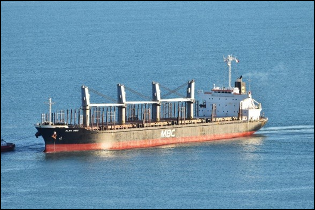
New TAIC Final Report presents crucial lessons for ship operations, human factors, and Pilot training. A bulk carrier ship, under conduct of harbour pilot, went off course in strong wind while entering Bluff Harbour. Its anchors failed to deploy in time, and it contacted the seabed. Minor damage to ship hull, damage to 2 tugs, no personal injuries.
Executive summary Tuhinga whakarāpopoto
What happened
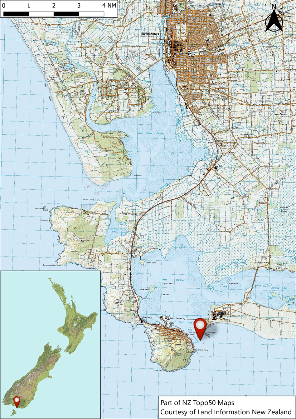
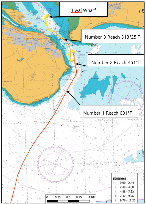
- On 28 November 2018, the Alam Seri was entering Bluff Harbour in a strong east-south-easterly wind under the conduct of a harbour pilot. Near the end of Number 1 Reach the vessel had to make a turn to port into Number 2 Reach. To achieve this the pilot ordered a succession of helm orders, and at about the same time ordered the engine speed to be reduced from half ahead to slow ahead.
- Shortly after entering Number 2 Reach the vessel began to veer off course to starboard, despite the helmsman applying full port rudder. The pilot ordered the engine speed to be increased to half ahead again to provide better steering control, and called for early assistance from two harbour tugs that were routinely waiting ahead to assist. However, concerned about the decreasing available safe water, the pilot then ordered the engine to be set to full astern and asked the crew to deploy both anchors. The crew were not able to deploy either anchor in time to provide assistance.
- The Alam Seri was brought under control using astern engine power and the assistance of the two tugs, but not before momentarily making contact with the seabed near the Inner Davey beacon. Both tugs were damaged during the event and their towlines parted (maritime term for the separation or breakage of a rope or cable) while bringing the Alam Seri under control.
- The Alam Seri’s underwater hull suffered paint abrasion as a result of making contact with the seabed, and above the waterline the hull was damaged as a result of contact with one of the tugs.
Why it happened
- The strong east-south-easterly wind, acting on the starboard side of the ship, was creating a strong starboard turning moment that could not be countered by the application of full port rudder. The resulting turning moment to starboard produced by the wind on the accommodation block exceeded the steering capability produced by water flow over the rudder when the engine was reduced from half to slow ahead.
- The delayed deployment of the anchors likely resulted in the vessel not stopping as soon as it could have, although it is uncertain whether the anchors would have prevented the ship from contacting the seabed if they were deployed when ordered.
- The bridge team did not have a shared understanding of the manoeuvring capabilities of the vessel in the weather conditions at the time, or of how the planned turn from Number 1 to Number 2 Reach would be achieved in the east-south-east conditions.
- The absence of electronic charting and information aids on the Alam Seri likely reduced the bridge team’s situational awareness, particularly during the manoeuvres to regain the channel following the incident.
What we can learn
- Successful ship-handling (manoeuvring of a vessel in circumstances requiring precise and skilful movement of the rudder and engine) and manoeuvring centres on balancing the forces acting on the vessel. On this occasion the bridge team did not share a common understanding with the pilot of how the reduction in engine speed and the relative wind speed and direction would affect the vessel’s steering capability.
- Manoeuvring actions and outcomes should be discussed during the master-pilot exchange and the bridge team should agree on defined parameters for monitoring and initiating a challenge.
- When safety-critical equipment, such as an anchor, is required to be available for immediate use in the event of an emergency, any factors affecting its immediate use should be communicated and discussed during the master-pilot exchange.
Who may benefit
- Vessel operators, port operators, harbour managers, pilotage providers, flag state administrators, maritime training establishments and classification societies may all benefit from the information contained in this report.
Factual information Pārongo pono
Narrative
- At 1648 (Times in this report are in New Zealand Daylight Saving Time, Universal Coordinated Time + 13 hours) on 28 November 2018, the bulk carrier Alam Seri completed its sea passage from Bunbury, Australia to Bluff, New Zealand. The vessel stopped and drifted until it was directed to proceed to the pilot boarding area.
- The pilot was scheduled to board at 1900, half an hour before the predicted time of slack water at the harbour entrance. At 1822 the Alam Seri commenced manoeuvring towards the pilot boarding area. The pilot boarded at 1854 and arrived on the bridge two minutes later. The bridge team consisted of the master, third officer, helmsman and pilot.
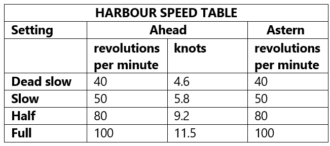
- The master informed the pilot that the engine was set to full ahead (see Table 1) and the vessel’s heading was 040 degrees true (°) (degrees measured clockwise from true north. Throughout this report the vessel’s heading is written as ###ⷪⷪ measured in degrees from true north). The pilot requested a course of 020° then commenced the master-pilot exchange of information.
- The master-pilot exchange of information included (the vessel’s voyage data recorder was downloaded and provided sound recordings from the bridge and the status of various navigation and technical systems on board):
- the vessel’s draughts and expected under-keel clearance
- relevant navigation marks, including leading marks
- the state of the tide and the expected tidal influence on the inward passage
- the use of tugs
- the mooring configuration and the berth and its minimum working depth
- the requirement for crew to be standing by on the forecastle with both anchors ready to be let go
- confirmation that the engine, steering gear and rudder indicators were in good working order
- radio channels and the use of closed-loop communication
- the pilot’s expectation that the vessel’s bridge team would monitor the vessel’s progress, and challenge if they were unsure about any of the pilot’s actions.
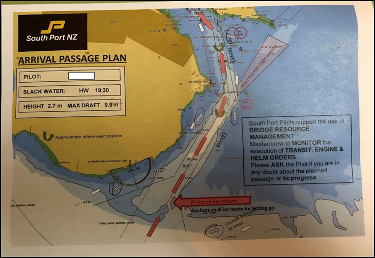
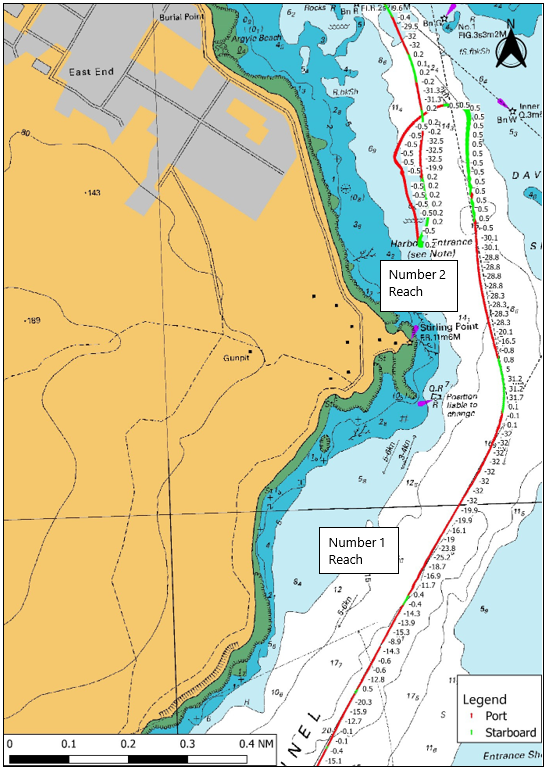
- Figure 3 shows a page from the pilot’s arrival passage plan. It detailed the planned courses and speeds and the direction of the tidal stream.
- Shortly afterwards the chief officer, the boatswain and two able-bodied seamen went forward to clear away the anchors and stand by for the inward passage. On the way forward the chief officer requested, and received, permission to wait inside the forecastle space, which offered protection against the wind and spray. Once the anchors had been cleared the chief officer and the forward standby team took shelter in the forecastle space.
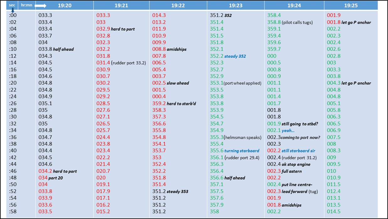
- At approximately 1903 the pilot took the conn from the master and adjusted the course to bring the vessel in line with the leading marks on Number 1 Reach. At 1920:10, as the Alam Seri approached Number 2 Reach, the pilot requested half ahead on the engine. Shortly after ordering this engine speed reduction, the pilot requested that the helm (the means, such as a steering wheel, by which a vessel’s steering is controlled) be placed hard to port (the left side of a vessel when facing forward) to initiate the turn into Number 2 Reach (see Figure 5).
- At 1921:50, as the vessel’s heading passed through 020°, the pilot requested that the helm be put amidships (when a vessel’s steering is centred, to attain 0° of rudder angle) and the engine speed be reduced further to slow ahead. At 1922:27 the pilot ordered the helm to be put hard to starboard to arrest the swing to port. The pilot then requested the helmsman to steady the ship’s heading on 353°. Eight seconds later the pilot amended this to a heading of 352°.
- The pilot then used the very-high-frequency radio to communicate with the tugs, the Te Matua and the Hauroko. The pilot briefed the skippers of both tugs on the planned requirements for manoeuvring the Alam Seri to the berth.
- While the pilot briefed the tug skippers, the Alam Seri’s helmsman was having difficulty steadying the ship on the new heading of 352°. The helmsman informed the bridge team that the vessel was still turning to starboard with almost maximum port helm applied.
- At 1923:49, after verifying that the engine was set on slow ahead, the pilot ordered half ahead. The third officer increased the engine speed to half ahead.
- The pilot then called the tugs and told the tug skippers that the Alam Seri was not responding to the helm and that their assistance would be required. Meanwhile, the helmsman had almost stopped the ship swinging to starboard (see Appendix 1). Nevertheless, at 1924:43 the pilot ordered the engine to be stopped and then set to full astern. The third officer carried out the orders immediately.
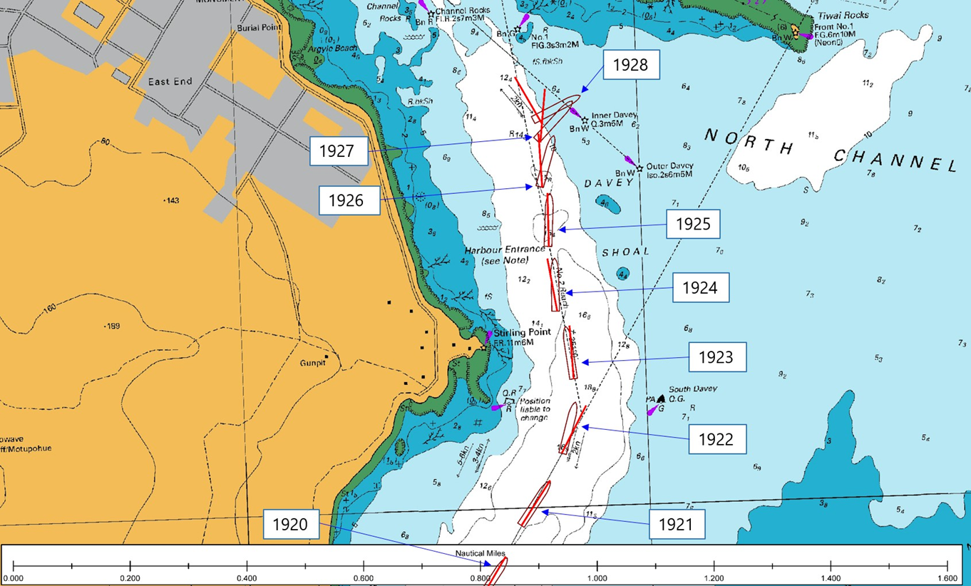
- Under the combined effect of the wind and its propeller turning astern, the Alam Seri began to veer to starboard east of Number 2 Reach (see Figure 6). The pilot instructed the tug skippers to keep the tugs clear because the ship was about to deploy an anchor. At 1925:04 the pilot instructed the master to let go the port anchor. The master relayed the order to the chief officer and waited for confirmation that the anchor had been let go.
- Between 1925 and 1929 the vessel continued to slow under the effect of its engines turning astern, but it was still closing towards the Inner Davey beacon (see Figure 5). The pilot continued giving instructions to the tug skippers, and frequently requested speed and depth information from the bridge team.
- Meanwhile, the crew had not succeeded in deploying the port anchor. When they had released the port anchor’s brake the port anchor had not dropped from the hawse pipe. The master and pilot agreed to let go the starboard anchor instead, but when the brake was released that too failed to deploy.
- Three minutes after the engine had been set to full astern, the Alam Seri stopped and began moving astern. By that time the forward part of the vessel had crossed the 10-metre (m) sounding line and the bow was very close to the Inner Davey beacon.
- At approximately 1929 the crew succeeded in deploying the starboard anchor, but it was no longer required and was immediately recovered.
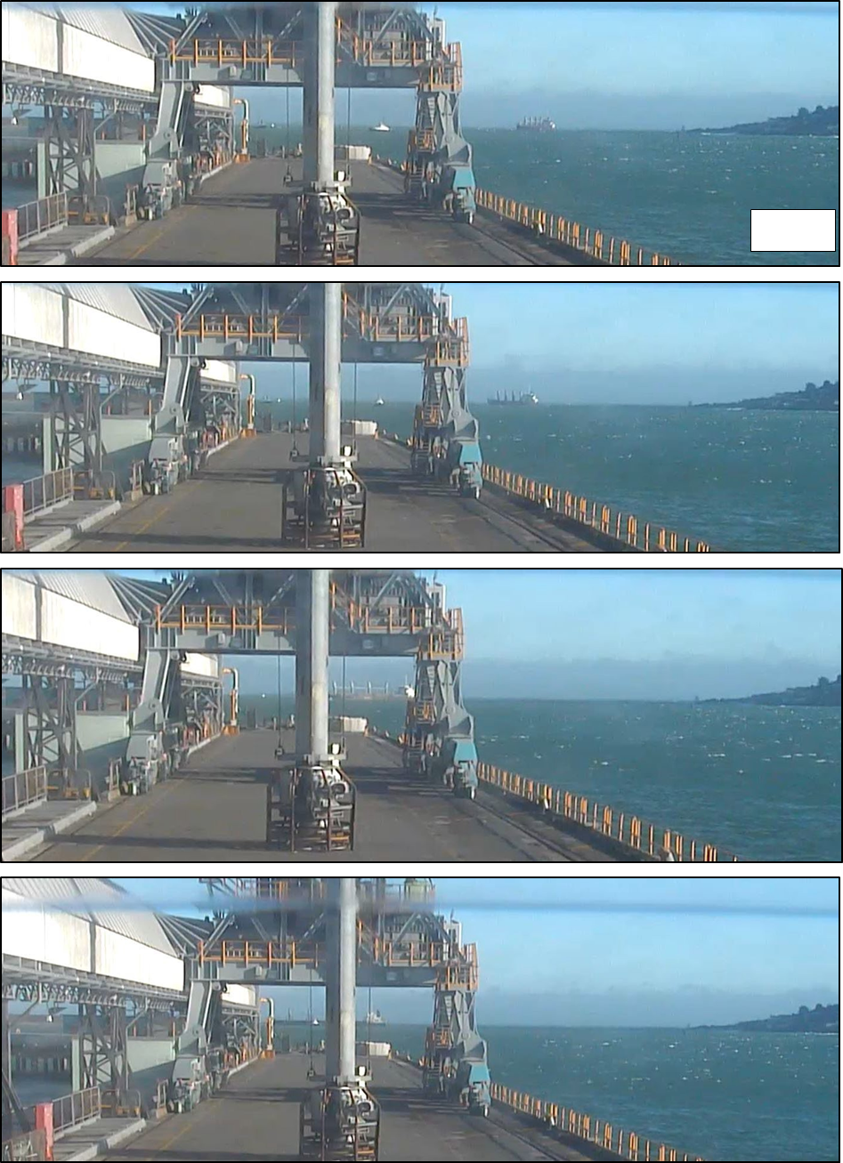
- A closed-circuit television camera (CCTV), located on Tīwai Wharf, recorded the occurrence. Images from the recording are shown in Figures 6 and 7 and can be referenced with the time stamps shown in Figure 5.
- The Alam Seri began to move astern and track to the west of Number 2 Reach (see Figure 5) towards Stirling Point.
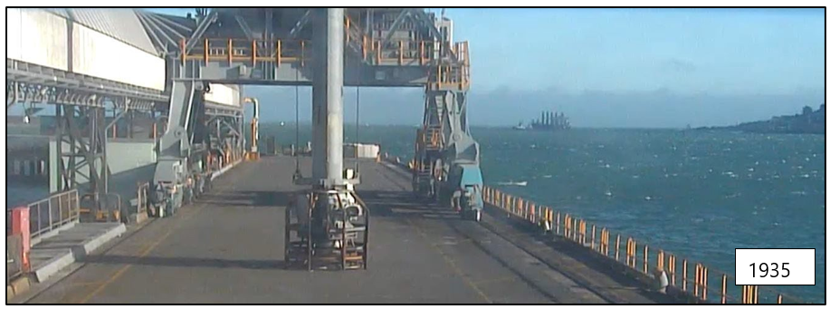
- At 1933 the Hauroko was secured to the stern of the Alam Seri, and the Te Matua was secured forward at 1935 (see Figure 7).
- At 1942 the Te Matua’s towline parted. Shortly afterwards a replacement line was run and the Te Matua was reconnected.
- As the pilot recovered control of the Alam Seri, both the tugs and the Alam Seri were damaged when the tugs contacted the ship while manoeuvring at close quarters and in the rough seas.
- At 1945, with the assistance of both tugs, the pilot conned the vessel into Bluff Harbour. At about 2010, while turning off the berth, the towline on the aft tug, the Hauroko, parted. A new towline was secured at 2018 and the Alam Seri was secured alongside Tīwai Wharf by 2100.
Personnel information
- The Alam Seri’s master had held the rank since 2007 and had worked for the vessel operator for three years. The master had joined the Alam Seri on 27 August 2018.
- The chief officer had sailed in the rank of chief officer since 2012, and had joined the Alam Seri on 25 October 2018.
- The third officer had sailed as a boatswain for 11 years before completing deck officer training and certification. The incident voyage was the third officer’s first voyage as a qualified watchkeeping officer.
- The pilot held a New Zealand Master unlimited certificate of competency and had been employed by South Port since 1995. The pilot had been trained following South Port’s approved pilot training and proficiency plan and attained the full qualification as an unlimited pilot for Bluff Harbour in 1997.
Environmental information
- Pilotage in the Port of Bluff is limited by wind and tide conditions. Vessels have opportunities to enter the port either side of high and low water. Pilotage is not attempted when wind speeds are consistently in excess of 35 knots.
- Bulk carriers of the same size and type as the Alam Seri have a restricting wind limit set at 35 knots. However, the direction from which the wind is blowing and other factors such as a vessel’s draught and manoeuvrability are taken into account when a job-specific pilotage plan is formulated.
- At the time of the incident there was a strong east-south-east wind (the compass direction east-south-east is the same as 112.5° true. Compass directions are more commonly used to describe wind directions). The wind had been from the east for the previous 10 days.
- High-water slack water at the harbour entrance was predicted to occur at around 1930. The pilot had indicated on the pilotage passage plan that the Alam Seri would transit the harbour entrance reaches with the last of the flood tide.
Other relevant information
Navigation with a pilot embarked – regulations and standards
- In addition to gaining their seagoing qualifications under the International Convention on Standards of Training, Certification and Watchkeeping for Seafarers (STCW), maritime pilots are trained specifically in ship-handling, tug management and emergency procedures. Pilots must also retain profound knowledge of all aspects of the pilotage area and its port facilities. A pilot becomes part of the bridge team for the act of pilotage and their specialist skills and local knowledge enhance the capability of the vessel’s bridge team. However, the presence of a pilot does not relieve the master and crew of their duties and responsibility for the safe navigation of the vessel.
-
The International Maritime Organization’s Resolution A.960 (International Maritime Organization Resolution A.960 Recommendations on Training and Certification and Operational Procedures for Maritime Pilots other than Deep-Sea Pilots, January 2004) states that:
masters and bridge officers have a duty to support the pilot and ensure that his/her actions are monitored at all times
and that:
The master, bridge officer and pilot share a responsibility for good communications and understanding of each other’s role for the safe conduct of the vessel in pilotage waters.
Vessel manoeuvrability
- A vessel’s manoeuvrability is affected by several factors, including its intrinsic design, and a number of external influences. These factors include, but are not limited to:
- the relative wind speed and direction and the surface area of the vessel exposed to the wind
- the water current
- the depth of water below the keel
- the rudder type and size and the angle it is capable of achieving
- the ship’s speed through the water and consequential flow past the rudder
- the speed of the engine/propeller and the consequential flow past the rudder.
- The resultant combination of all these forces will determine the speed, accelerations and direction at which the ship will travel. The bridge team must monitor how these forces are affecting the progress of the ship, and predict how they are likely to affect it in the immediate future.
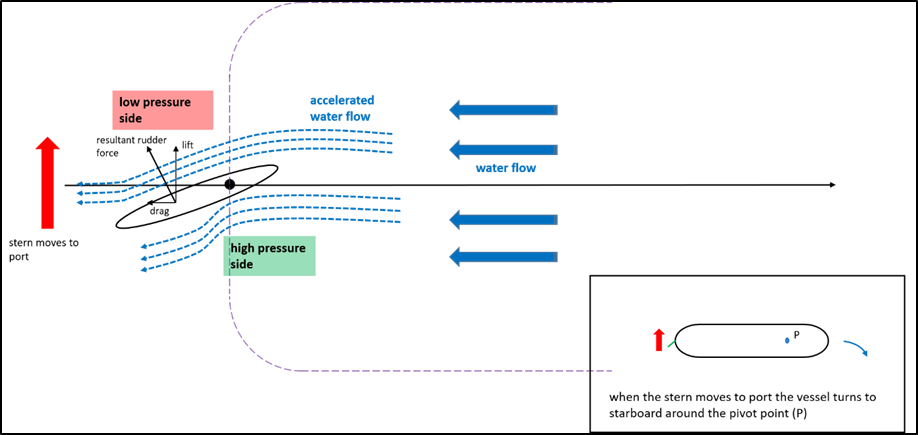
- A vessel’s rudder is the usual means by which the turning moments (the rudder’s force acting over the distance to the vessel’s pivot point, resulting in a turning effect) can be balanced. Similar to airflow over an aircraft wing, water moving past the angled aerofoil shape of the rudder creates low and high pressure sides (see Figure 8). The resulting lift on the low pressure side moves the stern in that direction and the ship changes direction around its pivot point.
- The Alam Seri had the typical configuration for manoeuvring bulk carriers – one propeller and one rudder.
- The Alam Seri’s steering gear was tested in the presence of a classification society surveyor and found to be in good working order. The surveyor added a new recommendation to the certificate of class: that the damage to the hull that had occurred when the Alam Seri and the tug Hauroko made heavy contact undergo a special examination within three months.
- A visual examination of the anchor windlasses showed no immediate abnormalities or modifications that could have prevented the anchors deploying.
Analysis Tātaritanga
Introduction
- No mechanical or equipment failure contributed to this incident.
- The environmental conditions when the Alam Seri was inbound to Bluff Harbour were not usual for the port, but were not exceptional either. The prevailing winds for the port are from the southwest quarter. On this occasion the wind was from the east and had been blowing from that direction for several days prior.
- Numerous similar inward transits have been successfully made, by Bluff pilots, in easterly conditions over the years. Similar transits have also been successfully practised in a simulator environment.
- There was nothing unusual about the Alam Seri’s manoeuvring characteristics. The vessel had a standard configuration like many other similar-sized bulk carriers. While the conditions were challenging, the ship should have been capable of making the entrance without incident in the conditions on the day.
- The following section analyses the circumstances surrounding the event to identify the factors that increased the likelihood of the event occurring or increased the severity of its outcome. It also examines a safety issue that had the potential to adversely affect future operations.
Contact with the seabed
- On 2 December 2018 a dive company conducted an underwater inspection of the Alam Seri’s hull at Tīwai Point. The diver inspected from the bottom of the hull to the first metre of the flat side for the entire length of the vessel.
- The inspection was recorded on video by the diver. A subsequent report described fresh scrapes on the flat bottom of the vessel at positions approximately 20 m and 30 m from the bow. The largest of these scrapes was 2 m by 0.4 m and, in places, down to bare steel. Additionally, the diver found two small scrapes approximately 8 m along the bottom of the stern tube. The largest of these scrapes was 0.1 m by 0.1 m. No cracks or dents were evident and there was no damage that affected the vessel’s seaworthiness.
- The Alam Seri’s passage plan used a program that predicted high water at 1907 local time, at a height of 2.62 m. The same tidal prediction program estimated a height of tide of 2.60 m at 1930. The tide predictions published by Land Information New Zealand predicted high water at 1857 local time, at a height of 2.70 m. The closest charted depth to where the Alam Seri was brought to a halt measured 6.40 m which meant that at the time of the incident and the location where the Alam Seri halted, there was a depth of approximately 9.00 m to 9.10 m.
- The Alam Seri’s draughts measured 8.76 m forward and 9.27 aft and so a mean draught of 9.02 m. Given the draughts in relation to the available depth of water at the time of the incident, it is very likely that the fresh scrapes found during the diver’s underwater hull inspection were caused by the vessel contacting the seabed during this incident.
Vessel manoeuvrability
Wind
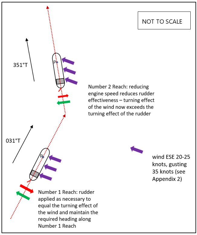
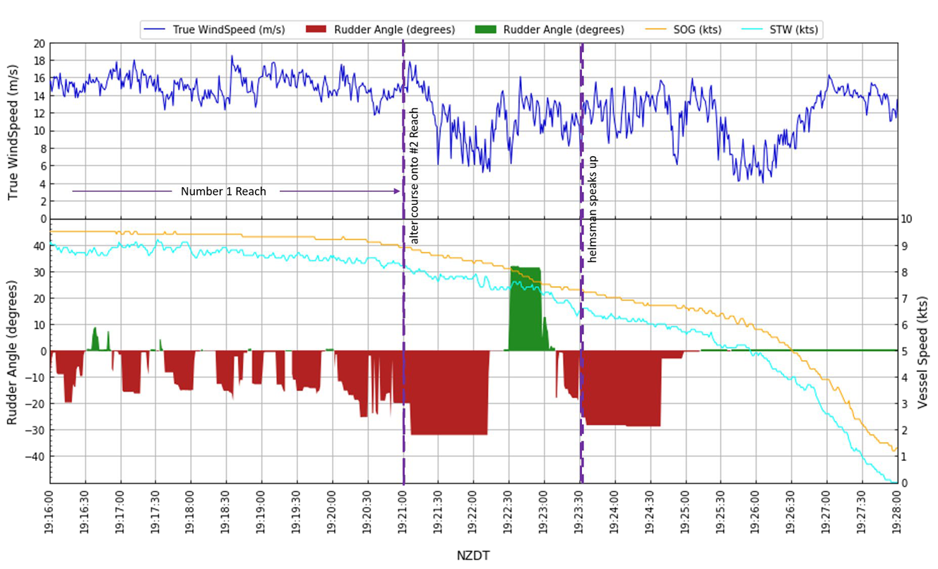
- When the Alam Seri transited Number 1 Reach, the engine was set on full ahead and the speed through the water was about 8.5 knots (Wind data provided by NIWA (the National Institute of Water and Atmospheric Research) to South Port, recorded at Number 3 beacon in the harbour entrance channel. These wind speeds were verified by cross-checking the wind speed data captured by the vessel’s instruments and saved on its voyage date recorder). The wind was from the east-south-east at a strength of about 25 knots, gusting to 32 knots and the vessel’s heading was approximately 031°, almost at right angles to the wind direction.
- The wind acted on the starboard side of the vessel, and with the accommodation block located aft there was a greater surface area aft of the vessel’s pivot point for the wind to act on (see Figure 9). This caused the tendency of the stern to move to port and the heading of the vessel to change to starboard, commonly referred to as ‘rounding up into the wind’ (see Figure 10). This tendency for the ship to veer to starboard was countered by the helmsman applying port rudder to maintain the courses ordered by the pilot (see Figure 11 and Appendix 2).
- The port helm required to maintain the course along Number 1 Reach appeared to go unnoticed by the bridge team (other than the helmsman) or at least there was no discussion among them about how it might affect the manner in which the port turn into Number 2 Reach would be made.

- At about 1920 the pilot ordered half ahead on the engine and about one minute later ordered hard to port to commence making the 40-degree turn into Number 2 Reach. When the helmsman reported that the vessel’s head was passing through 020° the pilot ordered the helm to be put to amidships, the engine speed to be reduced further to slow ahead, and then the helm to be put hard to starboard. The pilot’s intention was to slow the rate of turn to port in preparation for steadying up on the new course for Number 2 Reach. As soon as the helmsman reported that the rudder was hard to starboard, the pilot ordered the helmsman to steady up on a new heading of 352° to transit along Number 2 Reach. The swing to port halted and the vessel steadied up for about ten seconds before a swing to starboard developed. The helmsman applied port helm to counter the swing to starboard.
- The two successive engine reductions had two effects: they reduced the speed of the vessel (see Appendix 2) and they reduced the propeller wash past the rudder, thereby reducing the rudder’s effectiveness. As the vessel approached the new heading of 352°, the force of the wind was acting more on the starboard quarter (from the direction of between the starboard beam and right astern. The starboard beam is the area at right angles to the vessel’s fore and aft lines on the vessel’s starboard side). The wind’s effect of pushing the stern to port was therefore slightly reduced, but so too was the water flow over the rudder.
- The result was that when the helmsman attempted to steady the vessel’s head on 352°, they found that even with the rudder almost hard to port, the vessel was still swinging to starboard. The helmsman was prompt in telling the bridge team that the vessel was not manoeuvring as expected, and the pilot responded promptly by increasing the engine speed to half ahead. This had the effect of increasing the propeller wash past the rudder, thereby increasing the rudder’s effectiveness
- However, the vessel was by then coming close to leaving the channel of Number 2 Reach.
Current and tidal flow
- The pilot later submitted to the Commission that the sheer to starboard could have been the result of an adverse and unusual current. Currents are generally constant water flows generated by regional weather patterns. Tidal flows occur in conjunction with the rise and fall of the tides. The vertical motion of the tides near the shore causes the water to move horizontally, creating tidal flows. Tidal flows are influenced by interactions of the Earth, sun and moon, and in Bluff generally reverse direction every six hours.
-
A ship’s track through the water is the vector resulting from its heading and speed through the water. If the body of water through which the ship is transiting is moving, the result of the ship’s water-track vector and the current vector will be the ship’s track over the ground (ignoring any effect for wind, which introduces a leeway component). In open water the ship’s heading is usually unaffected by current. However, in shallower waters and narrow channels, the direction and speed of the current can be affected by the underwater topography. For large ships this could result in the influence of any current being different along its length. This can have an effect on the heading of the ship. The effect is generally predictable for given tidal flows in given channels. Pilots have local knowledge and will generally be aware of these effects and be ready to counter them should they occur.
It is feasible, however, that the sustained wind and sea conditions from the east in the 10 days prior to this event may have caused an unpredicted and unusual pattern of currents in the Bluff Harbour entrance channel, and that this may have, in combination with other factors identified in this report, had some influence on the direction of the ship as it made its turn into Number Two Reach.
Options for recovery
- The bridge team had two options available to recover the planned track: continue with increased engine speed and improved rudder effectiveness; or bring the vessel to a stop as soon as possible and engage the assistance of the tugs.
- The pilot was conscious of the limited amount of safe water ahead and chose the second option and ordered the engine astern.
- Evidence from the voyage data recorder showed it was about as likely as not that the attempt to increase speed had just started to take effect. The vessel’s head was beginning to turn back to port when the order was given to stop the vessel (see Appendix 1). However, this information was not readily apparent to the pilot and the bridge team because the Alam Seri was operating with minimal electronic aids to navigation. The decreasing availability of safe water ahead and the need to keep the ship’s speed under control for the berthing manoeuvre close inside the harbour likely influenced the pilot’s decision to stop the vessel by using astern propulsion. Given the circumstances, the pilot’s decision was understandable and a reasonable course of action.
- The pilot ordered the engine full astern and the port anchor to be let go. The port anchor could not be released and an attempt to release the starboard anchor also failed. This is discussed later in the analysis. Using the engine full astern in a timely manner helped to reduce the speed sufficiently, so that when the vessel did briefly ground there was no significant damage.
- After the pilot called the tugs they were available to assist within minutes. The port’s pilotage passage plan and operating procedures required the tugs to be available to assist inbound vessels at Number 2 Reach and, if required, at Number 1 Reach, but this was at the pilots’ discretion. The normal practice was for the tugs to be secured shortly after an inbound vessel entered Number 3 Reach. Although in this case earlier tug assistance may have proved beneficial, sea conditions would likely have limited the tugs’ effectiveness and increased the risk for tug operations. Even within Number 2 Reach, both tugs suffered damage and broken towlines while assisting in the recovery.
Bridge resource management
Safety issues: The level of bridge resource management on the bridge did not meet industry good practice. The bridge team could not effectively monitor the execution of the pilotage because they did not have an agreed specific pilot plan, or agreed monitoring parameters appropriate to the weather conditions at the time.
- The International Chamber of Shipping Bridge Procedures Guide describes an effective bridge team as one that “will manage efficiently all the resources that are available and promote good communication and teamwork”. Bridge resource management is a system that is used to manage the risk of a single-point failure – whether an equipment failure or a decision-based lapse or error – leading to a navigational incident. Members of the bridge team monitor the vessel’s progress against a defined passage plan and they monitor the manoeuvring inputs used to achieve the intended path of the vessel. When a member of the bridge team identifies a departure from the plan, or is unsure of the intentions of the person conning the vessel, a query or challenge should be raised.
- The International Maritime Organization’s (IMO’s) Resolution A.960 (IMO Resolution A.960(23): Recommendations on Training and Certification and Operational Procedures for Maritime Pilots Other Than Deep-Sea Pilots, adopted 5 December 2003) provides guidance to pilotage authorities on managing pilot training, and outlines recommended operational procedures. The IMO recommends that an information exchange between a master and a pilot be a process that continues for the duration of the pilotage. The content should include navigational procedures, local conditions and rules and the ship’s characteristics, and other information determined as relevant by the navigation demands of the specific pilotage operation.
- Communication and teamwork are essential to achieving efficient bridge resource management. The Alam Seri had its intended track drawn onto a paper chart, which essentially followed the middle of the channel and direction on the chart for each of the Reaches. These courses and distances were also described in a written passage plan. The vessel’s courses were similar to those depicted on the port passage plan provided by the pilot. However, the detail of how the vessel was going to achieve the tracks was missing from the vessel’s plan and were generic on the pilot’s passage plan. There was in effect no agreed pilotage plan specific to the existing conditions. The pilot indicated to the Master the direction and effect of the remaining tide. However, there was no discussion about wheel-over points and the amount of helm to achieve each alteration in course. The master commented on the strong wind and the pilot and the master spoke about the wind in general, but there was no indication that either thought that the wind would adversely affect the vessel as it transited the port entrance. The pilot and the vessel’s bridge team did not discuss what actions were intended to execute the alteration of course into Number 2 Reach in the weather conditions at the time.
- During the master-pilot exchange prior to the incident, the bridge team were asked to challenge the pilot’s actions if they were at all concerned. In the absence of an agreed passage plan specific to the pilotage task, this request set no boundaries and could have been interpreted differently from person to person.
- As the ship transited Number 1 Reach, the amount of port helm required(see Figure 11) to maintain the desired course should have engendered a discussion among the bridge team about the effect of the wind and how that would affect the vessel making the turn into Number 2 Reach. There was no such discussion, so the bridge team had no way of knowing what adjustments the pilot was making to the standard approach to allow for the conditions on the day.
Electronic navigational aids
- As an existing cargo vessel with a gross tonnage between 10,000-20,000, the Alam Seri was required by the International Convention for the Safety of Life at Sea to have an electronic chart display and information system (ECDIS) installed. However, the Alam Seri had a compliance date of July 2018 or the date of the next survey. The Alam Seri was scheduled to have an ECDIS installed during the next survey period, in December 2018. As a result the Alam Seri was not fitted with an ECDIS at the time of the incident, and the vessel’s primary method of navigation was paper charts.
- Although the port company provided portable pilot units (PPUs) for pilots to use, the pilot was not using a PPU at the time of the incident. A PPU provides a pilot with an electronic navigation display, plots a vessel’s current and past positions, and calculates the vessel’s predicted movements based on the current detected parameters. These parameters include the actual GPS track (speed and direction made good) of the vessel and the rate of any turn resulting from the various influences of rudder, wind and current. A PPU would have proved useful in the absence of any ship ECDIS or other chart plotter.
- Consequently, the only real-time means available to the bridge team for determining the vessel’s exact movements were radar and visual navigation.
- Electronic charting and information aids provide numerous benefits to bridge teams through increasing their situational awareness. The benefits include the ability to display their vessels’ real-time positions and predicted future movements. Corridors of safe navigation based on a ship’s draught and available depth of water can be displayed on the screen, giving instant visual awareness of whether the ship has left, or is predicted to leave, the safe navigation corridor. Other layers of information can also be displayed, such as contingency areas outside the safe navigation zone but where the ship will not ground or contact the bottom.
- Although traditional methods of navigation can be effective and should also be used, they lack the additional features and information outputs of electronic navigation aids. Importantly, the predictive features of electronic navigation aids such as ECDISs and PPUs might have informed the bridge team on whether, by leaving the engine speed on half ahead for slightly longer, it would have been possible to stay clear of the grounding zone and regain the safe navigation zone.
- It is likely that these electronic navigation aids would have improved the bridge team’s situational awareness and alerted them earlier that the vessel was unable to maintain its course on Number 2 Reach. The availability of electronic charting and information aids would have also likely assisted the pilot and the master to better assess the options available and aided their decision-making for recovering from the situation.
- Since the incident, all pilots at South Port have been issued with PPUs and trained in their use. They are carried on all pilotage jobs.
Pilot training and proficiency
Safety issue: Pilot currency and proficiency assessments were not implemented as required by South Port’s pilot training and proficiency plan.
- At the time of the incident, the South Port Safety Management Manual (the safety management manual) was considered to be consistent with the standards of the New Zealand Port and Harbour Marine Safety Code (Port and Harbour Marine Safety Code New Zealand, 2016 Edition, Maritime New Zealand). The safety management manual was based on a formal safety assessment that had been conducted in 2003 to determine guidelines and decision criteria for pilotage services and the risk management of marine infrastructure. As of 29 November 2018 the manual was in its eighth edition.
- The safety management manual covered standard procedures for arrivals and departures, the use of tugs, the application of decision criteria, emergency procedures and other procedures deemed appropriate. One of the procedures addressed the issue of a vessel not responding to starboard helm while transiting Number 1 Reach in west-to south-west winds. The procedure stated that when a vessel approached the harbour entrance and started veering towards the shoreline, and did not respond to starboard helm within a reasonable period of time, the pilot “shall cause the vessel to be stopped in the water using the vessel’s engine and anchors as deemed necessary”.
- Although the circumstances that led to the Alam Seri’s loss of control in a south-east wind were not specifically mentioned, the pilot adopted the same principle to avoid or reduce the consequences of a grounding.
- The control measures listed in the safety management manual to prevent a loss of manoeuvrability included:
- professional, well-trained pilot staff
- simulator training (crash stops)
- tug assistance whilst vessel under pilotage
- vessel to inform the pilot if there are any deficiencies in the bridge equipment, engines or anchors or any other factor that may affect safe pilotage.
- To ensure that pilots were well trained and proficient, the safety management manual included a pilot training and proficiency plan called the South Port Pilot and Tugmaster Training Manual (the training manual). This had been developed by South Port to train and maintain competent pilots in the Bluff and Stewart Island pilotage areas, and had been approved by Maritime New Zealand. It required pilots to progress through each pilot licence grade by means of practice, assessment and time.
- To maintain currency for the Bluff pilotage area, the training manual required every pilot to undergo an internal annual review, which was carried out by a designated South Port pilot. Additionally, a four-yearly external assessment of proficiency was required, to be carried out by an external assessor. Maritime Rules Part 90: Pilotage also required a pilot to complete an annual assessment of proficiency in the preceding 12 months to maintain currency. In the five years prior to the incident, the pilot had completed annual assessments of proficiency at Bluff in 2013, 2015, 2016 and 2017. The pilot’s most recent annual assessment of proficiency at Bluff had been conducted in April 2017, 19 months prior to the incident, which meant they were seven months overdue for their next annual assessment. The pilot had undergone an independent assessment by an external assessor within the Fiordland pilotage area in 2018, during the passenger cruise season. However, that external assessor had not held a current pilot licence for the Bluff pilotage area, so the external assessment could not be counted as an annual assessment of proficiency for the pilot.
- Some aspects of a pilot’s proficiency, for example bridge resource management, can be satisfactorily assessed outside a licensed pilotage area. However, aspects relating specifically to the Bluff pilotage area cannot be adequately assessed in another area (determined after consultation with members of the New Zealand Maritime Pilots Association, master mariners, and Maritime New Zealand).
- External assessments are an important aspect of the pilot check and audit programme. They are an important mechanism for detecting and remedying any potential bad practices or habits that can form over time, ones not necessarily picked up by peers who are deeply imbedded in the same system culture. This is particularly important for experienced pilots.
- The training manual also required pilots to attend simulator training every four years and refresher training such as advanced pilots training every four years. The pilot had last attended an advanced pilots training course in November 2015 and simulator training in February 2017. Bridge resource management is a topic covered in the advanced pilot course and is often practised during the simulator training courses.
- The accumulated knowledge and experience of pilots is a major risk control measure for the safe navigation of commercial vessels in New Zealand ports. Although pilots do not take command of vessels (masters always retain command of vessels in New Zealand ports), vessel operators still place a great deal of trust in pilots’ local knowledge, skills and experience.
- An analysis of 20 years of the pilot’s operation records found that the pilot had conducted 20 inward transits in strong winds from the south-east quadrant (refer to Appendix 2 for historical weather data for Bluff). Previous simulator training exercises had provided pilots with opportunities to operate in strong easterly and south-easterly winds. One simulator session had been carried out to ensure that large container vessels would be capable of making the turn into Number 2 Reach in south-east winds. These are examples of the knowledge and experience a pilot can bring to a port operation. Additionally, good, active bridge resource management techniques and adherence to training and development requirements can help to minimise the risk of systemic accidents.
- The Commission has made a recommendation to the Chief Executive of South Port that they ensure South Port’s safety management system develops measures to make certain that pilot training and proficiency requirements are being met as per the training manual.
Readiness of critical standby equipment
- The use of anchors to recover from a navigation emergency is a critical recovery control to prevent adverse outcomes. Industry best practice, as contained in the International Chamber of Shipping Bridge Procedures Guide, requires operational and emergency checklists to ensure that vessels’ equipment, such as anchors, is tested and ready for use. An important item in the pre-arrival and pre-departure checklists is a verification that anchors are clear and ready for immediate use.
- The Alam Seri’s pre-arrival checklist at Bluff confirmed that the anchors were clear and ready for use, as did the vessel’s pilot card. Additionally, the pilot’s job sheet, signed by the master, confirmed that the vessel was free of defects and that the anchors were ready for immediate use.
- However, when the order was given to let go the port anchor, the brake was released and the anchor did not deploy. Three attempts were made, through lowering and heaving the anchor a short distance under power on the windlass, to try to free it before the master ordered the chief officer to try the starboard anchor. The starboard anchor did not deploy and had to be lowered and raised under power before it dropped on the third attempt. By this time the vessel had stopped and the anchor was no longer required.
- The operator’s safety management system categorised the anchor windlasses as critical standby equipment. The planned maintenance schedules required greasing of the windlasses every four months and brake testing every six months.
- An analysis of the planned maintenance records showed that the windlasses had been greased more frequently than required by the planned maintenance system.
- It could not be established why the anchors did not deploy when required. The starboard anchor had been used for routine anchoring outside ports in Australia and Asia during September and October 2018. However, during routine deployment there is not the same urgency to stop the vessel as there is in emergency anchoring. On some vessels the anchors do not run out freely due to their design and an anchor may require lowering from the hawse pipe prior to deployment. If that was the case for the Alam Seri, this is information that would have been expected to be discussed during the master-pilot exchange.
Appendix 1. Change in vessel’s heading during the alteration into Number 2 Reach

Appendix 2. Vessel speed, wind speed and rudder angle values from the vessel’s voyage data recorder
Appendix 3. Historical weather data for Bluff
Bluff Harbour is located on the northern side of Foveaux Strait and lies near the centre of the latitude band known as the Roaring Forties. Weather patterns move from the west towards the east and the prevailing winds are from the west.
The New Zealand Port and Harbour Marine Safety Code requires regional councils and port operators to work together to develop their respective safety management systems. The Bluff Harbour risk assessment, conducted for the regional council, correctly identified that westerly winds were more prevalent over Southland. It also referred to South Port’s pilotage procedures and operational limits as risk control measures.
When easterly winds occur, they are likely to be associated with a weather pattern known as a low-index situation. A low-index situation happens when there is an intense anticyclone south of New Zealand and low pressure over the Tasman Sea or the North Island. Once established, this weather pattern can cause easterly winds to persist over southern New Zealand for prolonged periods (The Climate and Weather of Southland, 2nd Edition. Macara, G R., NIWA 2013). During these conditions, the wind and sea have an uninterrupted flow across the approaches to Bluff Harbour. There is no shelter from the land and there is unlimited fetch (the distance of water affected by wind-wave development, measured between the observer and the wind origin), resulting in rough sea conditions in the area of Number 2 Reach. In the more prevalent westerly wind conditions, Number 2 Reach is relatively sheltered from the land and has calmer sea conditions. Therefore, easterly winds present a higher risk on Number 2 Reach than the prevailing westerly wind conditions.
On the day of the incident, synoptic charts showed that there was an anticyclone to the south of New Zealand and relatively low pressure over central New Zealand, which created an easterly wind pattern. There had been strong easterly winds over Southland for the previous 10 days.
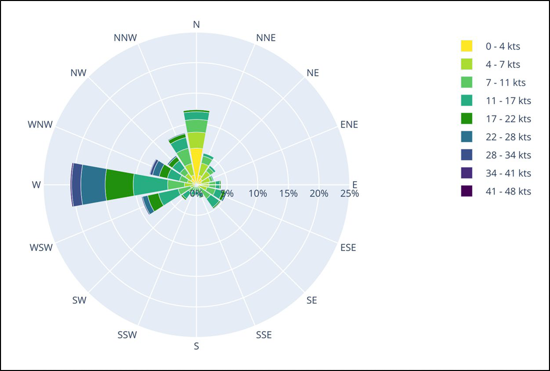
Year-round wind observations were analysed for 2017, 2018 and 2019. Figure 12 shows that the dominant wind direction at Tīwai Point, close to the approach channel, was westerly, and that winds from the southeast quadrant (directions between east and south) were infrequent and rarely resulted in speeds exceeding a moderate to fresh breeze (Beaufort wind scale force 4, moderate breeze (11-16 knots), force 5, fresh breeze (17-21 knots)).
The wind speed and direction in the approach channel for the month of November was also analysed. Data from 2016, 2017 and 2018 (see Figure 13) showed that the winds had been stronger in the approach channel than at Tīwai Point. Although the November data over three years showed that almost 25% of the recorded winds had been from the south-easterly quadrant, the data showed that in November 2018 specifically, the weather patterns over Southland had produced stronger, more frequent south-easterly winds than usual.